1980s Maps of Kodiak Island, Alaska
Explore 12 historic maps of Kodiak Island from the 1980s. These maps offer a rare glimpse into what life looked like during the 1980s — showing old roads, neighborhoods, homes, and landmarks that have changed or disappeared over time.
Whether you're researching your family's past, planning a metal detecting trip, or studying how Kodiak Island's landscape evolved across the 1980s, these high-resolution maps are a powerful tool for exploring the history of this region.
- Focus on a specific era: All maps on this page are from the 1980s, giving you a focused view of this time period.
- See what’s changed: Compare century-old streets, trails, and buildings to today's modern landscape using overlays and satellite layers.
- Research with precision: Use these maps for genealogy, historical research, land use analysis, or educational projects.
- View, download, or print: Maps are fully viewable online in high resolution, and can be downloaded or printed for your own records.
Start exploring Kodiak Island's history through authentic maps from the 1980s. This is your window into the past.
Kodiak Island, AK maps
(12)- 1987 Map of Kodiak C-1 SW, 1988 Print
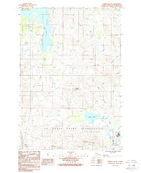
 1987 Kodiak C-1 SW1988 Print · USGSKodiak Island's rugged eastern shoreline is captured in the late eighties, showing the strategic maritime and mountainous terrain south of Chiniak. Researchers can trace the coastal Chiniak Road toward the US Coast Guard Reservation or locate the uniquely named Hidden Lakes.
 - 1987 Map of Kodiak D-1 SW, 1988 Print
 1987 Kodiak D-1 SW1988 Print · USGSKodiak Island’s rugged coastline and military presence are captured in the late eighties, featuring the strategic U S Coast Guard Reservation. Researchers can trace the layout of Woody Island and Long Island, including interior features like Dolgoi Lake and Elephant Lake.
 - 1987 Map of Kodiak C-2 NW, 1988 Print
 1987 Kodiak C-2 NW1988 Print · USGSKodiak Island's maritime and military landscape comes into focus in the late eighties, centered on the strategic waters of Womens Bay. Researchers can trace early infrastructure across the US Coast Guard Reservation and locate coastal landmarks like Panamaroff and the Nyman Peninsula.2 unique versions available
 - 1987 Map of Kodiak C-2 NE, 1988 Print
 1987 Kodiak C-2 NE1988 Print · USGSThe coastal interface of Kodiak Island is captured here in the late eighties, documenting the military and aviation footprint of the region. Researchers can trace the boundaries of the US Coast Guard Reservation and locate local landmarks such as Cliff Point and Finny Beach.
 - 1987 Map of Kodiak C-1 NW, 1988 Print
 1987 Kodiak C-1 NW1988 Print · USGSKodiak Island’s rugged coastline and maritime hazards are documented in the late eighties as they appeared before modern environmental shifts. Map collectors and researchers can trace the detailed shoreline of Long Island and identify navigation points like Humpback Rock and Isthmus Point.
 - 1987 Map of Kodiak B-2 NE, 1988 Print
 1987 Kodiak B-2 NE1988 Print · USGSKodiak Island's rugged southern coast is documented here in the late 1980s, showing a landscape defined by state recreation lands and military outposts. Researchers can trace the infrastructure of the US Coast Guard Reservation or locate remote landmarks like Rose Tead Lake and Narrow Cape.
 - 1987 Map of Kodiak C-1 SE, 1988 Print
 1987 Kodiak C-1 SE1988 Print · USGSKodiak Island’s eastern coastline comes into focus during the late eighties, showing the transition from the boreal interior to the open sea. Trace the shore from Chiniak Lagoon down to Cape Greville to locate survey markers like GEO STA 60333.
 - 1987 Map of Kodiak C-1 NE, 1988 Print
 1987 Kodiak C-1 NE1988 Print · USGSThe open sea of the Gulf of Alaska met the rugged shores of the Kodiak archipelago in the late eighties. Maritime historians can trace coastal hazards like Rock Hole and land features including Ugak Island and Chiniak Island.
 - 1987 Map of Kodiak B-1 NW, 1988 Print
 1987 Kodiak B-1 NW1988 Print · USGSThe Kodiak Island coastline and Ugak Island are documented here in the late eighties, showing the rugged intersection of land and sea. Researchers can trace coastal landmarks like Narrow Cape, Barry Lagoon, and the offshore Lone Rocks.
 - 1987 Map of Kodiak D-2 SW, 1988 Print
 1987 Kodiak D-2 SW1988 Print · USGSKodiak Island in the late 1980s was a critical hub of maritime and aviation activity, centered around the sprawling U S Coast Guard Reservation. Trace the infrastructure of the day from the Kodiak Airport to the inland Anton Larsen Road and Buskin Lake.2 unique versions available
 - 1987 Map of Kodiak C-2 SE, 1988 Print
 1987 Kodiak C-2 SE1988 Print · USGSKodiak Island at the end of the 1980s shows the coastal convergence of the Marin Range and the waters of Kalsin Bay. You can trace the primary road networks including Chiniak Road and find localized landmarks like the Gaging Station and Brookers Lagoon.
 - 1987 Map of Kodiak D-2 SE, 1988 Print
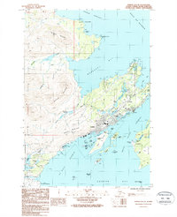 1987 Kodiak D-2 SE1988 Print · USGSKodiak Island comes to life in the late eighties, showing the bustling waterfront of Kodiak and the surrounding coastal outposts. Researchers can trace the development of Fort Abercrombie or locate the settlement of Aleksashkina on Woody Island.2 unique versions available
End of results
Showing maps 1-12 of 12
Top cities of Kodiak Island
- Kodiak historical maps
- Old Harbor historical maps
- Port Lions historical maps
- Ouzinkie historical maps
- Akhiok historical maps
- Larsen Bay historical maps
Frequently asked questions
- What are the different types of historical maps available for Kodiak Island?
- What is the oldest map of Kodiak Island?
- Where can I purchase historical maps of Kodiak Island for my home or office?
- Where can I download high-res historical maps of Kodiak Island?
- Are there historical topographic maps available for Kodiak Island?
- Is there historical aerial imagery available for Kodiak Island?
- Where are historical maps of Kodiak Island sourced from?