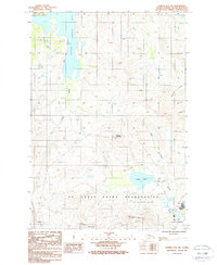
1987 Map of Kodiak D-2 SW
USGS Topo · Published 1988About this map
Larsen Bay and the surrounding peaks of Kodiak Island define this 1987 provisional survey, which captures the industrial and military infrastructure near the island's primary hub. The landscape is dominated by the massive U S Coast Guard Reservation and the Kodiak Airport, where researchers can locate specific infrastructure like the substation, radio towers, and a gravel pit. The inland terrain rises sharply toward Pyramid Mountain and Barometer Mountain, while the Anton Larsen Road provides the primary corridor through the valley toward the bay.
Find a feature on this map
23 named features on this map. Tap any name to fly to it.
Don’t see what you’re looking for? This feature index may not catch every label — zoom into the map to look around manually.
Map Details
Editions of this 1987 Kodiak D-2 SW Map
2 editions found
Other maps of this area

1947 · Kodiak D-3
USGS Topo · 1:63,360

1949 · Kodiak C-2
USGS Topo · 1:63,360

1949 · Kodiak D-2
USGS Topo · 1:63,360

1949 · Kodiak D-3
USGS Topo · 1:63,360

1950 · Kodiak D-3
USGS Topo · 1:63,360

1951 · Kodiak D-2
USGS Topo · 1:63,360

1952 · Kodiak
USGS Topo · 1:250,000

1952 · Kodiak C-3
USGS Topo · 1:63,360

1954 · Kodiak C-3
USGS Topo · 1:63,360
1987 · Kodiak C-2 NW
USGS Topo · 1:25,000