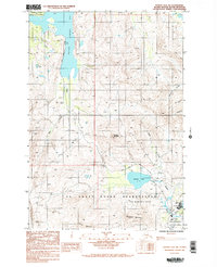
1987 Map of Kodiak D-2 SW
USGS Topo · Published 1988About this map
The U S Coast Guard Reservation dominates the southern landscape of this 1980s Alaskan survey, situated between the high peaks of the interior and the shoreline infrastructure. The Kodiak Airport serves as a focal point for transportation near Lake Louise and the Buskin River, while the Anton Larsen Road provides a critical overland link across the island toward Larsen Bay. Dramatic elevation changes define the region, with Pyramid Mountain, Barometer Mountain, and Erskine Mountain forming a formidable backdrop to the coastal activities.
Find a feature on this map
24 named features on this map. Tap any name to fly to it.
Don’t see what you’re looking for? This feature index may not catch every label — zoom into the map to look around manually.
Map Details
Editions of this 1987 Kodiak D-2 SW Map
2 editions found
Other maps of this area

1947 · Kodiak D-3
USGS Topo · 1:63,360

1949 · Kodiak C-2
USGS Topo · 1:63,360

1949 · Kodiak D-2
USGS Topo · 1:63,360

1949 · Kodiak D-3
USGS Topo · 1:63,360

1950 · Kodiak D-3
USGS Topo · 1:63,360

1951 · Kodiak D-2
USGS Topo · 1:63,360

1952 · Kodiak
USGS Topo · 1:250,000

1952 · Kodiak C-3
USGS Topo · 1:63,360

1954 · Kodiak C-3
USGS Topo · 1:63,360
1987 · Kodiak C-2 NW
USGS Topo · 1:25,000