Old Maps of Kodiak Island, Alaska for Academic Research
Study the evolution of Kodiak Island with 419 high-resolution historic maps. Whether you're teaching, researching, or modeling changes in land use, these maps provide essential visual documentation of urban, environmental, and geographic change.
- Analyze long-term change: Track patterns in development, transportation, and natural features.
- Ideal for environmental or urban studies: Support academic projects with primary historical map data.
- Use in the classroom or lab: Educators and researchers rely on these maps to bring historical context to life.
These maps are a powerful tool for teaching, research, and visualizing how Kodiak Island has changed over the decades.
Kodiak Island, AK maps
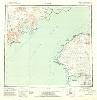
(419)- 1943 Map of Ugashik, 1958 Print
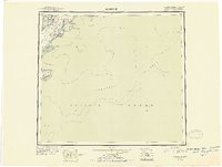
 1943 Ugashik1958 Print · USGSThe remote Alaska Peninsula is captured here in the 1940s, showing a wilderness of volcanic peaks and vast coastal drainages. You can trace early 20th-century outposts like Pilot Point and Lee Cabin set against landmarks like Mt Peulik and the waters of Becharof Lake.3 unique versions available
 - 1947 Map of Kodiak D-3, 1966 Print
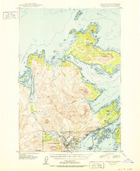
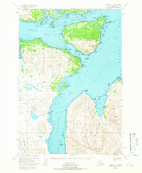 1947 Kodiak D-31966 Print · USGSThe Kodiak Archipelago's intricate coastlines and islands are captured here just after the mid-century. Trace the maritime geography of Port Lions and the mountainous stretches of the Kodiak National Wildlife Refuge near Whale Island.3 unique versions available
 - 1948 Map of Mt Katmai, 1954 Print
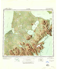
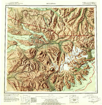
 1948 Mt Katmai1954 Print · USGSKatmai National Monument appears in the late 1940s as a landscape of dramatic volcanic activity and displaced settlements. Researchers can trace the geological impact of the 1912 eruption via the Valley of Ten Thousand Smokes or locate early habitation sites like Savonoski (Abandoned).
 - 1948 Map of Ugashik, 1954 Print
 1948 Ugashik1954 Print · USGSThe remote reaches of the Alaska Peninsula are documented here during the late 1940s, highlighting the early footprint of coastal settlements and mountain passes. Researchers can trace the layout of Kanatak and Pilot Point or locate isolated landmarks like Lee's Cabin and The Gas Rocks.
 - 1949 Map of Ugashik
 1949 Ugashik1949 Print · USGSThe Alaska Peninsula in the late 1940s reveals a wild landscape of salmon-rich rivers and volcanic peaks. Researchers can trace remote coastal settlements like Pilot Point and Kanatak, or locate landmarks such as Lee's Cabin and The Gas Rocks.2 unique versions available
 - 1949 Map of Kodiak C-2, 1953 Print
 1949 Kodiak C-21953 Print · USGSKodiak Island in the late 1940s reveals a critical military landscape defined by the U S Naval Reservation and its coastal defenses. Researchers can locate specialized infrastructure like the Military Seaplane Base and trace early roads like Burma Road past Old Womens Mountain.7 unique versions available
 - 1949 Map of Kodiak B-1 and B-2, 1954 Print
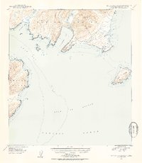 1949 Kodiak B-1 and B-21954 Print · USGSKodiak Island's rugged southeastern coastline is documented here just after the war, showing the intricate geography of its bays and peaks. Researchers can trace landforms and coastal features from Narrow Cape to Lake Rose Tead and Ugak Island.4 unique versions available
 - 1949 Map of Kodiak D-2, 1958 Print
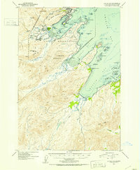
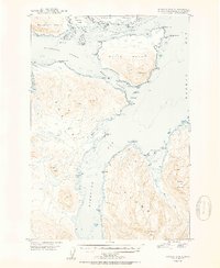
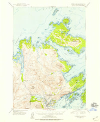 1949 Kodiak D-21958 Print · USGSKodiak Island and Spruce Island are shown just after the war as the region's naval presence and coastal settlements like Kodiak and Uzinki expanded. Researchers can trace military landmarks within the U S Naval Reservation or locate family-named features like Balika Basin and Melnitsa Lake.5 unique versions available
 - 1949 Map of Kodiak D-3, 1958 Print
 1949 Kodiak D-31958 Print · USGSKodiak Island and its surrounding straits appear as a complex network of coastal points and deep bays in the late 1940s. Maritime researchers can trace old landmarks across Whale Island and Raspberry Island, including Settler Cove and Dolphin Point.
 - 1949 Map of Kodiak A-3, 1964 Print
 1949 Kodiak A-31964 Print · USGSKodiak and Sitkalidak Islands appear in this mid-century survey of the Alaskan coast during the late 1940s. Researchers can trace the maritime boundaries of Sitkalidak Island and locate landmarks like Cape Barnabas and Table Island.3 unique versions available
 - 1949 Map of Kodiak C-1, 1964 Print
 1949 Kodiak C-11964 Print · USGSKodiak Island at the end of the 1940s reveals a maritime-centered landscape of rugged points and vital early aviation sites. Researchers can trace the coastline from Cape Chiniak to the Sacramento River or locate the historic Miller Airstrip.3 unique versions available
 - 1949 Map of Kodiak B-3, 1965 Print
 1949 Kodiak B-31965 Print · USGSKodiak Island's rugged eastern coastline in the late 1940s reveals a landscape defined by maritime industry and remote outposts. Researchers can locate the Kodiak Fisheries Cannery and Seaplane Base or trace the area around Eagle Harbor (Aban'd).3 unique versions available
 - 1949 Map of Kodiak D-1, 1965 Print
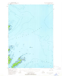 1949 Kodiak D-11965 Print · USGSKodiak Island's coastal islands and maritime approaches are charted here in the years following the war. Researchers can trace navigation aids and island geography from Woody Island to Long Island, including landmarks like Hamin Rocks Light.2 unique versions available
 - 1950 Map of Kodiak A-3
 1950 Kodiak A-31950 Print · USGSThe waters surrounding Sitkalidak Island are captured here during the post-war mapping of the Alaskan coast. Maritime researchers and historians can trace navigational landmarks like Cape Barnabas, Table Island, and the early boundaries of the Kodiak National Wildlife Refuge.
 - 1950 Map of Kodiak B-3
 1950 Kodiak B-31950 Print · USGSKodiak Island in the late 1940s reveals a rugged maritime landscape where remote industrial sites and fading settlements meet the sea. Maritime historians and genealogists can trace the Kodiak Fisheries Cannery on Shearwater Bay or the site of Eagle Harbor.2 unique versions available
 - 1950 Map of Kodiak D-3
 1950 Kodiak D-31950 Print · USGSThe Kodiak archipelago in the mid-century reveals a wild coastal landscape of deep fjords and mountainous islands. Maritime historians and researchers can trace the intricate shoreline from Whale Island to the peaks of Sharatin Mountain and Barabara Cove.2 unique versions available
 - 1951 Map of Kodiak D-1
 1951 Kodiak D-11951 Print · USGSCoastal Kodiak Island comes to life in the early post-war years, showcasing the maritime infrastructure and island outposts of the era. Maritime historians and researchers can trace local landmarks like Woody Island, the Hamin Rocks Light, and Hutchinson Road.2 unique versions available
 - 1951 Map of Kaguyak
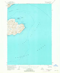
 1951 Kaguyak1951 Print · USGSThe southern tip of Kodiak Island and the Trinity Islands are mapped here in the early fifties, showing a remote maritime landscape. Researchers can trace coastal features such as Kaguyak, Cape Sitkinak, and the expansive Albatross Bank.2 unique versions available
 - 1951 Map of Kodiak B-1 and B-2
 1951 Kodiak B-1 and B-21951 Print · USGSKodiak Island coastal terrain and maritime features are documented here in the early fifties. Genealogists and researchers can trace the shoreline of Pasagshak Bay and locate landmarks like Narrow Cape and Ugak Island.2 unique versions available
 - 1951 Map of Kodiak D-2
 1951 Kodiak D-21951 Print · USGSKodiak Island during the early Cold War years shows a landscape heavily influenced by strategic defense and maritime trade. Researchers can trace the bounds of the Fort Greeley Military Reservation, locate the village of Uzinki, and follow the winding Pillar Mountain Road.2 unique versions available
 - 1951 Map of Trinity Islands
 1951 Trinity Islands1951 Print · USGSThe southwestern tip of Kodiak Island and the Trinity Islands are captured in the early fifties, detailing a remote landscape of fishing outposts and wildlife preserves. Researchers can trace the coastal layout of Akhiok, locate the Cannery near Alitak, and explore the topography of Sitkinak Island.
 - 1951 Map of Kodiak C-1
 1951 Kodiak C-11951 Print · USGSKodiak Island's northeastern coast and its mid-century maritime features appear here just after the war years. Researchers can trace landforms from Cape Chiniak to Boyer Peak and locate the remote Airstrip and Sacramento River.2 unique versions available
 - 1951 Map of Mt Katmai, 1952 Print
 1951 Mt Katmai1952 Print · USGSThe Alaska Peninsula at mid-century reveals a landscape of volcanic upheaval and empty settlements following the Great Eruption. Researchers can trace the vanished communities of Savonoski and Katmai Village or locate the Novarupta Volcano.11 unique versions available
 - 1951 Map of Karluk, 1952 Print
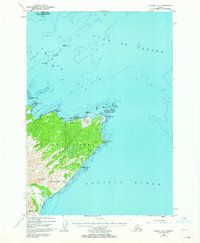
 1951 Karluk1952 Print · USGSThe Kodiak archipelago and the rugged Katmai coast are shown in the early fifties before statehood. Genealogists and historians can trace the early industrial footprint of the Cannery at Larsen Bay and the isolated settlement at Karluk.
 - 1951 Map of Seldovia, 1952 Print
 1951 Seldovia1952 Print · USGSThe lower Kenai Peninsula appears here in the early fifties as a network of coastal outposts and maritime landing sites. Researchers can trace early settlements like Seldovia, locate family-named points such as Millers Landing, and explore the limits of the Kenai National Moose Range.8 unique versions available
Showing maps 1-25 of 419
Top cities of Kodiak Island
- Kodiak historical maps
- Old Harbor historical maps
- Port Lions historical maps
- Ouzinkie historical maps
- Akhiok historical maps
- Larsen Bay historical maps
Frequently asked questions
- What are the different types of historical maps available for Kodiak Island?
- What is the oldest map of Kodiak Island?
- Where can I purchase historical maps of Kodiak Island for my home or office?
- Where can I download high-res historical maps of Kodiak Island?
- Are there historical topographic maps available for Kodiak Island?
- Is there historical aerial imagery available for Kodiak Island?
- Where are historical maps of Kodiak Island sourced from?