
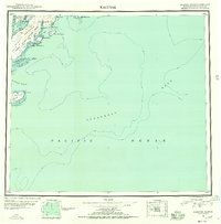
1951 Map of Kaguyak
USGS Topo · Published 1951About this map
The southern reaches of Kodiak Island and the neighboring Trinity Islands are the focus of this mid-century reconnaissance. The landscape is dominated by the Aliulik Peninsula and Hepburn Peninsula, where the Kodiak National Wildlife Refuge Boundary marks the interior wilderness. The settlement of Kaguyak sits along the coast of Kaguyak Bay, representing a sparse human footprint in an area primarily defined by deep bays like Alitak Bay and Deadman Bay.
Find a feature on this map
29 named features on this map. Tap any name to fly to it.
Don’t see what you’re looking for? This feature index may not catch every label — zoom into the map to look around manually.
Map Details
Editions of this 1951 Kaguyak Map
2 editions found
Other maps of this area

1949 · Kodiak A-3
USGS Topo · 1:63,360

1950 · Kodiak A-3
USGS Topo · 1:63,360

1951 · Trinity Islands
USGS Topo · 1:250,000

1951 · Karluk
USGS Topo · 1:250,000

1952 · Kodiak
USGS Topo · 1:250,000

1952 · Kaguyak
USGS Topo · 1:250,000

1952 · Karluk
USGS Topo · 1:250,000

1952 · Kaguyak D-5
USGS Topo · 1:63,360

1952 · Trinity Islands D-1
USGS Topo · 1:63,360

1952 · Karluk A-1
USGS Topo · 1:63,360