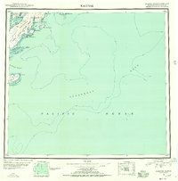
1951 Map of Kaguyak
USGS Topo · Published 1955About this map
Kaguyak sits on the southeastern edge of Kodiak Island, a remote coastal settlement positioned where the Aliulik Peninsula meets the northern reaches of the Pacific Ocean. This reconnaissance survey reflects the mid-century maritime landscape of the Third Judicial Division, focused on the intricate network of inlets and peninsulas that define this rugged coastline. Significant landmarks such as Hepburn Peninsula and Sitkinak Island delineate the passage of the Sitkinak Strait, while the interior is dominated by the Kodiak National Wildlife Refuge Boundary. Beyond the immediate shore, the map details the bathymetry of the Albatross Bank, highlighting the area's importance to deep-water navigation and fishing. The topography, compiled through photoalidade methods and trimetrogon photography, emphasizes the stark contrast between the sharp coastal peaks and the deep bays like Deadman Bay and Old Kaguyak Bay.
Find a feature on this map
29 named features on this map. Tap any name to fly to it.
Don’t see what you’re looking for? This feature index may not catch every label — zoom into the map to look around manually.
Map Details
Editions of this 1951 Kaguyak Map
2 editions found
Other maps of this area

1949 · Kodiak A-3
USGS Topo · 1:63,360

1950 · Kodiak A-3
USGS Topo · 1:63,360

1951 · Kaguyak
USGS Topo · 1:250,000

1951 · Trinity Islands
USGS Topo · 1:250,000

1951 · Karluk
USGS Topo · 1:250,000

1952 · Kodiak
USGS Topo · 1:250,000

1952 · Kaguyak
USGS Topo · 1:250,000

1952 · Karluk
USGS Topo · 1:250,000

1952 · Kaguyak D-5
USGS Topo · 1:63,360

1952 · Trinity Islands D-1
USGS Topo · 1:63,360