
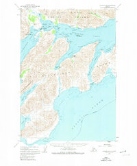
1950 Map of Kodiak A-3
USGS Topo · Published 1950About this map
Sitkalidak Island dominates this mid-century maritime study, separated from the larger Kodiak Island landmass by the deep waters of Sitkalidak Strait. The interior of the island is defined by steep relief, with elevations reaching over 1,500 feet, while the coastline is marked by significant navigational landmarks such as Cape Barnabas and the offshore Table Island. This survey captures the coastline just as portions were designated as part of the Kodiak National Wildlife Refuge, reflecting the era's focus on conservation and mapping of the Alaskan territory. Survey markers like Vabm 100 and Vabm 230 indicate the precise topographic control established during the 1949 field checks. The eastern edge of the map opens into the vast Gulf of Alaska and the Pacific Ocean, emphasizing the isolation and marine-dependent geography of this region south of the mainland.
Find a feature on this map
14 named features on this map. Tap any name to fly to it.
Don’t see what you’re looking for? This feature index may not catch every label — zoom into the map to look around manually.
Map Details
Editions of this 1950 Kodiak A-3 Map
This is the sole edition of this map. No revisions or reprints were ever made.
Other maps of this area

1949 · Kodiak B-1 and B-2
USGS Topo · 1:63,360

1949 · Kodiak A-3
USGS Topo · 1:63,360

1949 · Kodiak B-3
USGS Topo · 1:63,360

1950 · Kodiak B-3
USGS Topo · 1:63,360

1951 · Kaguyak
USGS Topo · 1:250,000

1951 · Kodiak B-1 and B-2
USGS Topo · 1:63,360

1952 · Kodiak
USGS Topo · 1:250,000

1952 · Kaguyak
USGS Topo · 1:250,000

1952 · Kodiak B-4
USGS Topo · 1:63,360
1952 · Kodiak A-4
USGS Topo · 1:63,360