
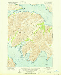
1950 Map of Kodiak B-3
USGS Topo · Published 1950About this map
Kodiak National Wildlife Refuge dominates the interior of this coastal survey, preserving a landscape defined by deep fjords and steep topographic relief. The coastline is heavily indented with significant water bodies including Ugak Bay to the north and Kiliuda Bay to the south. Commercial activity is represented by the Kodiak Fisheries Cannery located on Shearwater Bay, a site providing insight into the mid-century fishing industry and seasonal settlement patterns on Kodiak Island. The map records human footprints that were already receding by the late 1940s, most notably at Eagle Harbor, which is explicitly marked as abandoned. From Dangerous Cape to Outer Right Cape, the survey captures the navigational challenges of the Gulf of Alaska shoreline, where rocky points and remote coves like Saltery Cove and Santa Flavia Bay were essential landmarks for maritime transit and local wildlife management.
Find a feature on this map
25 named features on this map. Tap any name to fly to it.
Don’t see what you’re looking for? This feature index may not catch every label — zoom into the map to look around manually.
Map Details
Editions of this 1950 Kodiak B-3 Map
2 editions found
Other maps of this area

1949 · Kodiak C-2
USGS Topo · 1:63,360

1949 · Kodiak B-1 and B-2
USGS Topo · 1:63,360

1949 · Kodiak A-3
USGS Topo · 1:63,360

1949 · Kodiak B-3
USGS Topo · 1:63,360

1950 · Kodiak A-3
USGS Topo · 1:63,360

1951 · Kodiak B-1 and B-2
USGS Topo · 1:63,360

1952 · Kodiak
USGS Topo · 1:250,000

1952 · Kodiak C-3
USGS Topo · 1:63,360

1952 · Kodiak C-4
USGS Topo · 1:63,360

1952 · Kodiak B-4
USGS Topo · 1:63,360