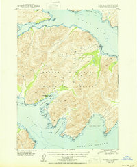
1950 Map of Kodiak B-3
USGS Topo · Published 1950About this map
The Kodiak National Wildlife Refuge dominates the interior of this coastal terrain, where the deeply indented shoreline of Kodiak Island meets the Gulf of Alaska. Industrial activity is localized at the Kodiak Fisheries Cannery on Shearwater Bay, reflecting the island's mid-century economic reliance on maritime resources. The geography is defined by significant landmarks such as Observation Point and Dangerous Cape, which provided critical navigation cues for the commercial vessels and fishing fleets of the era. Evidence of shifting human habitation is seen at Eagle Harbor (Aban'd), where a former settlement site sits near the water. Significant summits like VABM 2040 King and VABM 803 Yon serve as fixed points for this 1950 survey, which captures a landscape transitioning between established industry and wilderness preservation.
Find a feature on this map
38 named features on this map. Tap any name to fly to it.
Don’t see what you’re looking for? This feature index may not catch every label — zoom into the map to look around manually.
Map Details
Editions of this 1950 Kodiak B-3 Map
2 editions found
Other maps of this area

1949 · Kodiak C-2
USGS Topo · 1:63,360

1949 · Kodiak B-1 and B-2
USGS Topo · 1:63,360

1949 · Kodiak A-3
USGS Topo · 1:63,360

1949 · Kodiak B-3
USGS Topo · 1:63,360

1950 · Kodiak A-3
USGS Topo · 1:63,360

1950 · Kodiak B-3
USGS Topo · 1:63,360

1951 · Kodiak B-1 and B-2
USGS Topo · 1:63,360

1952 · Kodiak
USGS Topo · 1:250,000

1952 · Kodiak C-3
USGS Topo · 1:63,360

1952 · Kodiak C-4
USGS Topo · 1:63,360