1950s Maps of Akhiok, Alaska
Explore 4 historic maps of Akhiok from the 1950s. These maps offer a rare glimpse into what life looked like during the 1950s — showing old roads, neighborhoods, homes, and landmarks that have changed or disappeared over time.
Whether you're researching your family's past, planning a metal detecting trip, or studying how Akhiok's landscape evolved across the 1950s, these high-resolution maps are a powerful tool for exploring the history of this region.
- Focus on a specific era: All maps on this page are from the 1950s, giving you a focused view of this time period.
- See what’s changed: Compare century-old streets, trails, and buildings to today's modern landscape using overlays and satellite layers.
- Research with precision: Use these maps for genealogy, historical research, land use analysis, or educational projects.
- View, download, or print: Maps are fully viewable online in high resolution, and can be downloaded or printed for your own records.
Start exploring Akhiok's history through authentic maps from the 1950s. This is your window into the past.
Akhiok, AK maps
(4)- 1951 Map of Trinity Islands
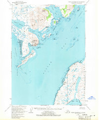
 1951 Trinity Islands1951 Print · USGSThe southwestern tip of Kodiak Island and the Trinity Islands are captured in the early fifties, detailing a remote landscape of fishing outposts and wildlife preserves. Researchers can trace the coastal layout of Akhiok, locate the Cannery near Alitak, and explore the topography of Sitkinak Island.
 - 1952 Map of Trinity Islands D-1, 1971 Print
 1952 Trinity Islands D-11971 Print · USGSSouthern Kodiak Island in the early fifties shows a landscape of remote fishing outposts and wildlife wilderness. Researchers can locate the Pacific American Fishery Cannery and the Seaplane Base near Akhiok, or trace the coastline from Russian Harbor to Moser Peninsula.3 unique versions available
 - 1954 Map of Trinity Islands D-1, 1955 Print
 1954 Trinity Islands D-11955 Print · USGSKodiak Island in the early fifties shows a remote landscape defined by the salmon industry and the Kodiak National Wildlife Refuge. Researchers can trace the coastal settlement at Akhiok and the industrial footprint of the Pacific American Fishery Cannery on Lazy Bay.
 - 1954 Map of Trinity Islands, 1956 Print
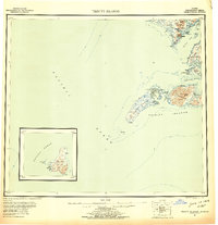 1954 Trinity Islands1956 Print · USGSThe southern reaches of Kodiak Island and its remote archipelagos are captured here in the mid-fifties. Researchers can trace the coastal layout of the Trinity Islands and locate isolated outposts like Akhiok or the Cabin sites on Chirikof Island.7 unique versions available
End of results
Showing maps 1-4 of 4
Frequently asked questions
- What are the different types of historical maps available for Akhiok?
- What is the oldest map of Akhiok?
- Where can I purchase historical maps of Akhiok for my home or office?
- Where can I download high-res historical maps of Akhiok?
- Are there historical topographic maps available for Akhiok?
- Is there historical aerial imagery available for Akhiok?
- Where are historical maps of Akhiok sourced from?