Old Maps of Akhiok, Alaska for Genealogy
Trace your family roots with 6 historic maps of Akhiok. These high-res maps reveal old neighborhoods, homesites, landmarks, and streets — helping you uncover where your ancestors lived and how the area evolved over time.
- Explore historic neighborhoods: Identify where your relatives may have lived in the 1800s or 1900s.
- Compare maps over time: Trace the changes in streets, buildings, and landmarks for multi-generational research.
- Perfect for genealogy & ancestry research: Used by family historians and researchers to map out lineage and migration.
These maps are an incredible resource for exploring your personal connection to Akhiok's past.
Akhiok, AK maps
(6)- 1951 Map of Trinity Islands
 1951 Trinity Islands1951 Print · USGSThe southwestern tip of Kodiak Island and the Trinity Islands are captured in the early fifties, detailing a remote landscape of fishing outposts and wildlife preserves. Researchers can trace the coastal layout of Akhiok, locate the Cannery near Alitak, and explore the topography of Sitkinak Island.
 - 1952 Map of Trinity Islands D-1, 1971 Print
 1952 Trinity Islands D-11971 Print · USGSSouthern Kodiak Island in the early fifties shows a landscape of remote fishing outposts and wildlife wilderness. Researchers can locate the Pacific American Fishery Cannery and the Seaplane Base near Akhiok, or trace the coastline from Russian Harbor to Moser Peninsula.3 unique versions available
 - 1954 Map of Trinity Islands D-1, 1955 Print
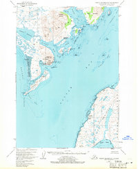
 1954 Trinity Islands D-11955 Print · USGSKodiak Island in the early fifties shows a remote landscape defined by the salmon industry and the Kodiak National Wildlife Refuge. Researchers can trace the coastal settlement at Akhiok and the industrial footprint of the Pacific American Fishery Cannery on Lazy Bay.
 - 1954 Map of Trinity Islands, 1956 Print
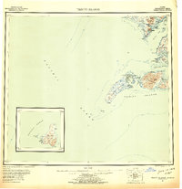 1954 Trinity Islands1956 Print · USGSThe southern reaches of Kodiak Island and its remote archipelagos are captured here in the mid-fifties. Researchers can trace the coastal layout of the Trinity Islands and locate isolated outposts like Akhiok or the Cabin sites on Chirikof Island.7 unique versions available
 - 2021 Map of Trinity Islands D-1 NE, 2021 Print
 2021 Trinity Islands D-1 NE2021 Print · USGSKodiak Island’s southern coastal reaches are documented in this contemporary survey of the Trinity Islands area. Maritime researchers can trace the jagged shorelines of Moser Peninsula and locate landmarks like Miller Island, Camp Cove, and Nelson Reef.
 - 2021 Map of Trinity Islands D-1 NW, 2021 Print
 2021 Trinity Islands D-1 NW2021 Print · USGSKodiak Island's southern coast comes into focus in the early 2020s, centered on the isolated village of Akhiok. Genealogists and researchers can trace local infrastructure like Akhiok Cem and Akhiok Airport alongside landmarks like Tungulura Mtn.
End of results
Showing maps 1-6 of 6
Frequently asked questions
- What are the different types of historical maps available for Akhiok?
- What is the oldest map of Akhiok?
- Where can I purchase historical maps of Akhiok for my home or office?
- Where can I download high-res historical maps of Akhiok?
- Are there historical topographic maps available for Akhiok?
- Is there historical aerial imagery available for Akhiok?
- Where are historical maps of Akhiok sourced from?