Old Maps of Akhiok, Alaska for Academic Research
Study the evolution of Akhiok with 6 high-resolution historic maps. Whether you're teaching, researching, or modeling changes in land use, these maps provide essential visual documentation of urban, environmental, and geographic change.
- Analyze long-term change: Track patterns in development, transportation, and natural features.
- Ideal for environmental or urban studies: Support academic projects with primary historical map data.
- Use in the classroom or lab: Educators and researchers rely on these maps to bring historical context to life.
These maps are a powerful tool for teaching, research, and visualizing how Akhiok has changed over the decades.
Akhiok, AK maps
(6)- 1951 Map of Trinity Islands
 1951 Trinity Islands1951 Print · USGSThe southwestern tip of Kodiak Island and the Trinity Islands are captured in the early fifties, detailing a remote landscape of fishing outposts and wildlife preserves. Researchers can trace the coastal layout of Akhiok, locate the Cannery near Alitak, and explore the topography of Sitkinak Island.
 - 1952 Map of Trinity Islands D-1, 1971 Print
 1952 Trinity Islands D-11971 Print · USGSSouthern Kodiak Island in the early fifties shows a landscape of remote fishing outposts and wildlife wilderness. Researchers can locate the Pacific American Fishery Cannery and the Seaplane Base near Akhiok, or trace the coastline from Russian Harbor to Moser Peninsula.3 unique versions available
 - 1954 Map of Trinity Islands D-1, 1955 Print
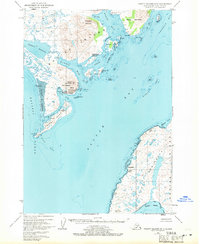
 1954 Trinity Islands D-11955 Print · USGSKodiak Island in the early fifties shows a remote landscape defined by the salmon industry and the Kodiak National Wildlife Refuge. Researchers can trace the coastal settlement at Akhiok and the industrial footprint of the Pacific American Fishery Cannery on Lazy Bay.
 - 1954 Map of Trinity Islands, 1956 Print
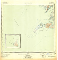 1954 Trinity Islands1956 Print · USGSThe southern reaches of Kodiak Island and its remote archipelagos are captured here in the mid-fifties. Researchers can trace the coastal layout of the Trinity Islands and locate isolated outposts like Akhiok or the Cabin sites on Chirikof Island.7 unique versions available
 - 2021 Map of Trinity Islands D-1 NE, 2021 Print
 2021 Trinity Islands D-1 NE2021 Print · USGSKodiak Island’s southern coastal reaches are documented in this contemporary survey of the Trinity Islands area. Maritime researchers can trace the jagged shorelines of Moser Peninsula and locate landmarks like Miller Island, Camp Cove, and Nelson Reef.
 - 2021 Map of Trinity Islands D-1 NW, 2021 Print
 2021 Trinity Islands D-1 NW2021 Print · USGSKodiak Island's southern coast comes into focus in the early 2020s, centered on the isolated village of Akhiok. Genealogists and researchers can trace local infrastructure like Akhiok Cem and Akhiok Airport alongside landmarks like Tungulura Mtn.
End of results
Showing maps 1-6 of 6
Frequently asked questions
- What are the different types of historical maps available for Akhiok?
- What is the oldest map of Akhiok?
- Where can I purchase historical maps of Akhiok for my home or office?
- Where can I download high-res historical maps of Akhiok?
- Are there historical topographic maps available for Akhiok?
- Is there historical aerial imagery available for Akhiok?
- Where are historical maps of Akhiok sourced from?