1940s Maps of Lake and Peninsula, Alaska
Explore 7 historic maps of Lake and Peninsula from the 1940s. These maps offer a rare glimpse into what life looked like during the 1940s — showing old roads, neighborhoods, homes, and landmarks that have changed or disappeared over time.
Whether you're researching your family's past, planning a metal detecting trip, or studying how Lake and Peninsula's landscape evolved across the 1940s, these high-resolution maps are a powerful tool for exploring the history of this region.
- Focus on a specific era: All maps on this page are from the 1940s, giving you a focused view of this time period.
- See what’s changed: Compare century-old streets, trails, and buildings to today's modern landscape using overlays and satellite layers.
- Research with precision: Use these maps for genealogy, historical research, land use analysis, or educational projects.
- View, download, or print: Maps are fully viewable online in high resolution, and can be downloaded or printed for your own records.
Start exploring Lake and Peninsula's history through authentic maps from the 1940s. This is your window into the past.
Lake and Peninsula, AK maps
(7)- 1943 Map of Ugashik, 1958 Print
 1943 Ugashik1958 Print · USGSThe remote Alaska Peninsula is captured here in the 1940s, showing a wilderness of volcanic peaks and vast coastal drainages. You can trace early 20th-century outposts like Pilot Point and Lee Cabin set against landmarks like Mt Peulik and the waters of Becharof Lake.3 unique versions available
 - 1945 Map of Nushagak Bay, 1954 Print
 1945 Nushagak Bay1954 Print · USGSNushagak Bay and the sprawling Alaskan coastline are captured in the mid-1940s, highlighting a landscape defined by salmon fishing and tidal waters. Researchers can locate remote outposts like Old Saltery, the busy Nushagak Cannery, and the coastal settlement of Clarks Point.
 - 1946 Map of Lake Clark, 1954 Print
 1946 Lake Clark1954 Print · USGSInterior Alaska during the mid-forties and early fifties reveals a remote landscape of glacial lakes and mountain peaks. You can trace early settlements at Nondalton, find the Old Village trail network, and locate the Tanalian Point Landing Field near the shores of Lake Clark.2 unique versions available
 - 1948 Map of Mt Katmai, 1954 Print
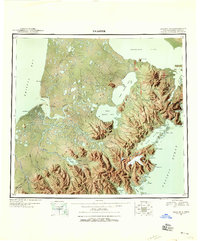
 1948 Mt Katmai1954 Print · USGSKatmai National Monument appears in the late 1940s as a landscape of dramatic volcanic activity and displaced settlements. Researchers can trace the geological impact of the 1912 eruption via the Valley of Ten Thousand Smokes or locate early habitation sites like Savonoski (Abandoned).
 - 1948 Map of Ugashik, 1954 Print
 1948 Ugashik1954 Print · USGSThe remote reaches of the Alaska Peninsula are documented here during the late 1940s, highlighting the early footprint of coastal settlements and mountain passes. Researchers can trace the layout of Kanatak and Pilot Point or locate isolated landmarks like Lee's Cabin and The Gas Rocks.
 - 1949 Map of Ugashik
 1949 Ugashik1949 Print · USGSThe Alaska Peninsula in the late 1940s reveals a wild landscape of salmon-rich rivers and volcanic peaks. Researchers can trace remote coastal settlements like Pilot Point and Kanatak, or locate landmarks such as Lee's Cabin and The Gas Rocks.2 unique versions available
 - 1949 Map of Nushagak Bay
 1949 Nushagak Bay1949 Print · USGSCoastal Alaska at the height of the mid-century salmon industry reveals a landscape of isolated canneries and subsistence camps. You can trace the shorelines to find sites like Nushagak Cannery, the Old Saltery, and the remote Igushik Cannery along the river.2 unique versions available
End of results
Showing maps 1-7 of 7
Top cities of Lake and Peninsula
- Kokhanok historical maps
- Newhalen historical maps
- Nondalton historical maps
- Port Heiden historical maps
- Egegik historical maps
- Pilot Point historical maps
See more
Frequently asked questions
- What are the different types of historical maps available for Lake and Peninsula?
- What is the oldest map of Lake and Peninsula?
- Where can I purchase historical maps of Lake and Peninsula for my home or office?
- Where can I download high-res historical maps of Lake and Peninsula?
- Are there historical topographic maps available for Lake and Peninsula?
- Is there historical aerial imagery available for Lake and Peninsula?
- Where are historical maps of Lake and Peninsula sourced from?