Old Maps of Chignik, Alaska for Metal Detecting
Plan your next treasure hunt with 3 historic maps of Chignik. Find old homesites, ghost towns, trails, and gathering spots that may be lost to time — perfect for identifying promising metal detecting locations.
- Locate forgotten sites: Uncover places like long-lost settlements, abandoned rail lines, or gathering spots.
- Plan better hunts: Use map overlays combined with LiDAR or satellite views to narrow in on historically rich areas.
- Made for detectorists: Thousands of hobbyists use these maps to discover relics, coins, and hidden history.
Use these historic maps to boost your research and find new opportunities beneath the surface of Chignik.
Chignik, AK maps
(3)- 1963 Map of Chignik B-2, 1967 Print
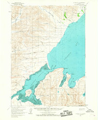 1963 Chignik B-21967 Print · USGSThe Alaska Peninsula coast in the early sixties reveals a busy maritime landscape centered on fishing and aviation. Researchers can locate the Seaplane Base Chignik, local Cannery sites, and family-named landmarks like Jerrys Point and Mensis Point.2 unique versions available
 - 1963 Map of Chignik, 1968 Print
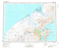 1963 Chignik1968 Print · USGSThe Alaska Peninsula in the mid-sixties is a world of volcanic peaks and isolated fishing outposts. Genealogists and historians can trace the foundations of Chignik and Meshik or locate remote Cabins near Chignik Lake and the Meshik River.3 unique versions available
 - 2020 Map of Chignik B-2 SE, 2020 Print
 2020 Chignik B-2 SE2020 Print · USGSThe coastal settlement of Chignik and the surrounding wilderness of the Alaska Peninsula are documented here in the early twenty-first century. Local history researchers can trace the shorelines of Anchorage Bay, identify the location of Chignik Airport, and locate landmarks like Chignik Mountain and the Chignik Spit.
End of results
Showing maps 1-3 of 3
Frequently asked questions
- What are the different types of historical maps available for Chignik?
- What is the oldest map of Chignik?
- Where can I purchase historical maps of Chignik for my home or office?
- Where can I download high-res historical maps of Chignik?
- Are there historical topographic maps available for Chignik?
- Is there historical aerial imagery available for Chignik?
- Where are historical maps of Chignik sourced from?