1900s (20th Century) Maps of Ivanof Bay, Alaska
Explore 4 historic maps of Ivanof Bay from the 1900s (20th Century). These maps offer a rare glimpse into what life looked like during the 1900s — showing old roads, neighborhoods, homes, and landmarks that have changed or disappeared over time.
Whether you're researching your family's past, planning a metal detecting trip, or studying how Ivanof Bay's landscape evolved across the 1900s, these high-resolution maps are a powerful tool for exploring the history of this region.
- Focus on a specific era: All maps on this page are from the 1900s, giving you a focused view of this time period.
- See what’s changed: Compare century-old streets, trails, and buildings to today's modern landscape using overlays and satellite layers.
- Research with precision: Use these maps for genealogy, historical research, land use analysis, or educational projects.
- View, download, or print: Maps are fully viewable online in high resolution, and can be downloaded or printed for your own records.
Start exploring Ivanof Bay's history through authentic maps from the 1900s. This is your window into the past.
Ivanof Bay, AK maps
(4)- 1951 Map of Stepovak Bay, 1952 Print
 1951 Stepovak Bay1952 Print · USGSThe Alaska Peninsula and Shumagin Islands are documented here during the early fifties, showing a remote maritime and coastal landscape. Researchers can trace early settlements and coastal landings such as Perryville, Bales Ldg, and the waters of Stepovak Bay.
 - 1963 Map of Stepovak Bay D-5, 1968 Print
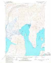 1963 Stepovak Bay D-51968 Print · USGSThe remote shores of the Kupreanof Peninsula are documented here in the early 1960s, showing the maritime economy and rugged geography of the Aleutian Range. Researchers can trace the layout of the Cannery at Ivanof Bay and identify isolated Cabins near Kupreanof Harbor.2 unique versions available
 - 1963 Map of Stepovak Bay, 1969 Print
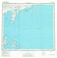 1963 Stepovak Bay1969 Print · USGSThe Alaska Peninsula and its maritime outposts are charted here during the 1960s, documenting a remote stretch of Pacific coastline. Researchers can locate the settlement of Perryville and trace coastal features like Sanborn Harbor, Red Bluff Mountain, and the Ivanof Bay coastline.3 unique versions available
 - 1969 Map of Stepovak Bay
 1969 Stepovak Bay1969 Print · USGSThe Alaska Peninsula and its offshore archipelagos are captured here in the late sixties, showing the remote coastal settlement of Perryville. Researchers can trace maritime routes through the Shumagin Islands and locate landmarks like Castle Rock and Mitrofania Island.
End of results
Showing maps 1-4 of 4
Frequently asked questions
- What are the different types of historical maps available for Ivanof Bay?
- What is the oldest map of Ivanof Bay?
- Where can I purchase historical maps of Ivanof Bay for my home or office?
- Where can I download high-res historical maps of Ivanof Bay?
- Are there historical topographic maps available for Ivanof Bay?
- Is there historical aerial imagery available for Ivanof Bay?
- Where are historical maps of Ivanof Bay sourced from?