1950s Maps of Newhalen, Alaska
Explore 4 historic maps of Newhalen from the 1950s. These maps offer a rare glimpse into what life looked like during the 1950s — showing old roads, neighborhoods, homes, and landmarks that have changed or disappeared over time.
Whether you're researching your family's past, planning a metal detecting trip, or studying how Newhalen's landscape evolved across the 1950s, these high-resolution maps are a powerful tool for exploring the history of this region.
- Focus on a specific era: All maps on this page are from the 1950s, giving you a focused view of this time period.
- See what’s changed: Compare century-old streets, trails, and buildings to today's modern landscape using overlays and satellite layers.
- Research with precision: Use these maps for genealogy, historical research, land use analysis, or educational projects.
- View, download, or print: Maps are fully viewable online in high resolution, and can be downloaded or printed for your own records.
Start exploring Newhalen's history through authentic maps from the 1950s. This is your window into the past.
Newhalen, AK maps
(4)- 1952 Map of Iliamna, 1953 Print
 1952 Iliamna1953 Print · USGSAlaska's interior and coastline meet in this early 1950s survey of the Lake Iliamna region. Researchers can trace remote settlements and camps such as Fish Village, Old Iliamna (Aband), and Hammerly Camp at the edge of the Katmai National Monument.4 unique versions available
 - 1954 Map of Iliamna C-6, 1964 Print
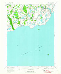 1954 Iliamna C-61964 Print · USGSIliamna Lake’s north shore and the settlement of Newhalen are documented here in the mid-fifties, before major modern development. Researchers can trace the early footprint of the Iliamna Airfield and the resource planning at Power Site Reserve No 485.2 unique versions available
 - 1954 Map of Iliamna C-5, 1965 Print
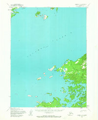 1954 Iliamna C-51965 Print · USGSIliamna Lake’s vast shoreline in the mid-1950s remains a remote frontier shaped by water and wilderness. Trace the small outposts at Seversens, explore the islands of Eagle Bay Island, and locate the natural shelter of Snug Harbor.2 unique versions available
 - 1957 Map of Iliamna, 1965 Print
 1957 Iliamna1965 Print · USGSSouthwestern Alaska in the late fifties centers on the massive waters of Iliamna Lake and its surrounding villages. Trace family roots and old routes at Old Roadhouse, Newhalen, and the Kamishak (Site) near the edge of Katmai National Monument.7 unique versions available
End of results
Showing maps 1-4 of 4
Top cities near Newhalen
Frequently asked questions
- What are the different types of historical maps available for Newhalen?
- What is the oldest map of Newhalen?
- Where can I purchase historical maps of Newhalen for my home or office?
- Where can I download high-res historical maps of Newhalen?
- Are there historical topographic maps available for Newhalen?
- Is there historical aerial imagery available for Newhalen?
- Where are historical maps of Newhalen sourced from?