
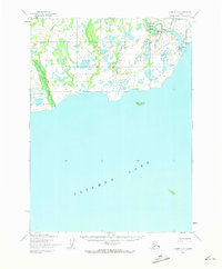
1954 Map of Iliamna C-6
USGS Topo · Published 1964About this map
Newhalen River flows into the expansive north shore of Iliamna Lake in this mid-century survey of the Alaska interior. The settlement of Newhalen sits at the river's mouth, serving as a primary point of human activity in an area otherwise defined by water and tundra. Just north of the settlement, the Iliamna Airfield indicates the region's reliance on bush aviation for connectivity.
Find a feature on this map
8 named features on this map. Tap any name to fly to it.
Don’t see what you’re looking for? This feature index may not catch every label — zoom into the map to look around manually.
Map Details
Editions of this 1954 Iliamna C-6 Map
2 editions found
Other maps of this area

1951 · Iliamna B-5
USGS Topo · 1:63,360

1951 · Iliamna B-7
USGS Topo · 1:63,360

1951 · Iliamna B-6
USGS Topo · 1:63,360

1952 · Iliamna
USGS Topo · 1:250,000

1954 · Iliamna C-5
USGS Topo · 1:63,360

1954 · Iliamna D-5
USGS Topo · 1:63,360
1954 · Iliamna B-5
USGS Topo · 1:63,360
1954 · Iliamna B-6
USGS Topo · 1:63,360
1954 · Iliamna C-7
USGS Topo · 1:63,360

1954 · Iliamna D-7
USGS Topo · 1:63,360