1950s Maps of Kobuk, Alaska
Explore 3 historic maps of Kobuk from the 1950s. These maps offer a rare glimpse into what life looked like during the 1950s — showing old roads, neighborhoods, homes, and landmarks that have changed or disappeared over time.
Whether you're researching your family's past, planning a metal detecting trip, or studying how Kobuk's landscape evolved across the 1950s, these high-resolution maps are a powerful tool for exploring the history of this region.
- Focus on a specific era: All maps on this page are from the 1950s, giving you a focused view of this time period.
- See what’s changed: Compare century-old streets, trails, and buildings to today's modern landscape using overlays and satellite layers.
- Research with precision: Use these maps for genealogy, historical research, land use analysis, or educational projects.
- View, download, or print: Maps are fully viewable online in high resolution, and can be downloaded or printed for your own records.
Start exploring Kobuk's history through authentic maps from the 1950s. This is your window into the past.
Kobuk, AK maps
(3)- 1951 Map of Shungnak
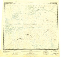 1951 Shungnak1951 Print · USGSNorthwest Alaska was just beginning to be mapped with modern precision in the early fifties, revealing the vast Kobuk and Selawik watersheds. Researchers can trace the riverfront at Shungnak, remote cabins, and high summits like Purcell Mountain.
 - 1955 Map of Shungnak, 1958 Print
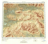 1955 Shungnak1958 Print · USGSUpper Kobuk River life in the mid-fifties centered on the village of Shungnak and the seasonal use of the surrounding wilderness. Researchers can trace remote cabins, old mining sites near Purcell Mtn, and the primitive Landing Area that served this Arctic frontier.6 unique versions available
 - 1955 Map of Shungnak D-2, 1959 Print
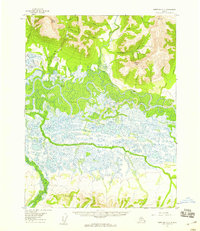 1955 Shungnak D-21959 Print · USGSThe Northwest Arctic in the mid-fifties is a landscape of winding waterways and remote outposts centered on the Kobuk River. Researchers can trace the early footprint of Kobuk, locate the Dahl Creek Airstrip, and find mineral interests at Asbestos Mountain.3 unique versions available
End of results
Showing maps 1-3 of 3
Top cities near Kobuk
Frequently asked questions
- What are the different types of historical maps available for Kobuk?
- What is the oldest map of Kobuk?
- Where can I purchase historical maps of Kobuk for my home or office?
- Where can I download high-res historical maps of Kobuk?
- Are there historical topographic maps available for Kobuk?
- Is there historical aerial imagery available for Kobuk?
- Where are historical maps of Kobuk sourced from?