Old Maps of Kobuk, Alaska for Genealogy
Trace your family roots with 5 historic maps of Kobuk. These high-res maps reveal old neighborhoods, homesites, landmarks, and streets — helping you uncover where your ancestors lived and how the area evolved over time.
- Explore historic neighborhoods: Identify where your relatives may have lived in the 1800s or 1900s.
- Compare maps over time: Trace the changes in streets, buildings, and landmarks for multi-generational research.
- Perfect for genealogy & ancestry research: Used by family historians and researchers to map out lineage and migration.
These maps are an incredible resource for exploring your personal connection to Kobuk's past.
Kobuk, AK maps
(5)- 1951 Map of Shungnak
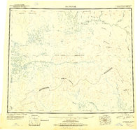 1951 Shungnak1951 Print · USGSNorthwest Alaska was just beginning to be mapped with modern precision in the early fifties, revealing the vast Kobuk and Selawik watersheds. Researchers can trace the riverfront at Shungnak, remote cabins, and high summits like Purcell Mountain.
 - 1955 Map of Shungnak, 1958 Print
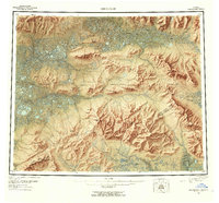 1955 Shungnak1958 Print · USGSUpper Kobuk River life in the mid-fifties centered on the village of Shungnak and the seasonal use of the surrounding wilderness. Researchers can trace remote cabins, old mining sites near Purcell Mtn, and the primitive Landing Area that served this Arctic frontier.6 unique versions available
 - 1955 Map of Shungnak D-2, 1959 Print
 1955 Shungnak D-21959 Print · USGSThe Northwest Arctic in the mid-fifties is a landscape of winding waterways and remote outposts centered on the Kobuk River. Researchers can trace the early footprint of Kobuk, locate the Dahl Creek Airstrip, and find mineral interests at Asbestos Mountain.3 unique versions available
 - 1964 Map of Shungnak
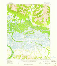
 1964 Shungnak1964 Print · USGSNorthwest Alaska in the mid-sixties is mapped here across the wild watersheds of the Kobuk River and Selawik River. Researchers can locate isolated settlements like Shungnak and Kobuk, or trace the path of the Arctic Circle through the Lockwood Hills.
 - 2016 Map of Shungnak D-2 NW, 2016 Print
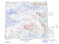
 2016 Shungnak D-2 NW2016 Print · USGSKobuk sits at a remote crossroads of river and air travel in the Northwest Arctic during the mid-2010s. Researchers can trace the path of the Dahl Creek Road as it connects Kobuk to the northern highlands near Inerevuk Mtn.
End of results
Showing maps 1-5 of 5
Top cities near Kobuk
Frequently asked questions
- What are the different types of historical maps available for Kobuk?
- What is the oldest map of Kobuk?
- Where can I purchase historical maps of Kobuk for my home or office?
- Where can I download high-res historical maps of Kobuk?
- Are there historical topographic maps available for Kobuk?
- Is there historical aerial imagery available for Kobuk?
- Where are historical maps of Kobuk sourced from?