Old Maps of Kupreanof, Alaska for Academic Research
Study the evolution of Kupreanof with 12 high-resolution historic maps. Whether you're teaching, researching, or modeling changes in land use, these maps provide essential visual documentation of urban, environmental, and geographic change.
- Analyze long-term change: Track patterns in development, transportation, and natural features.
- Ideal for environmental or urban studies: Support academic projects with primary historical map data.
- Use in the classroom or lab: Educators and researchers rely on these maps to bring historical context to life.
These maps are a powerful tool for teaching, research, and visualizing how Kupreanof has changed over the decades.
Kupreanof, AK maps
(12)- 1951 Map of Petersburg D-4, 1958 Print
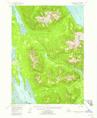 1951 Petersburg D-41958 Print · USGSKupreanof Island and the Lindenberg Peninsula are shown in the early 1950s when the wilderness was navigated by water and forest trail. Researchers can trace the Petersburg Trail past Petersburg Lake or locate isolated cabins along Petersburg Creek.4 unique versions available
 - 1952 Map of Petersburg, 1953 Print
 1952 Petersburg1953 Print · USGSSoutheast Alaska's intricate Alexander Archipelago comes to life in the early fifties, documenting a landscape of remote island settlements and maritime corridors. Genealogists and historians can trace coastal life in Petersburg and Wrangell, or locate early industry at Shakan and regional Mines.5 unique versions available
 - 1960 Map of Petersburg, 1966 Print
 1960 Petersburg1966 Print · USGSSoutheast Alaska's maritime landscape is captured here in the mid-1900s, showcasing the intricate island networks of the Alexander Archipelago. Researchers can trace historic shorelines and island settlements from Petersburg and Kake to the Wrangell Cemetery and the Stikine River.3 unique versions available
 - 1961 Map of Petersburg D-3, 1966 Print
 1961 Petersburg D-31966 Print · USGSSoutheast Alaska at the start of the 1960s centers on the bustling maritime hub of Petersburg along the Wrangell Narrows. Researchers can trace the waterfront infrastructure of the era, from the Seaplane Airport to the outlying settlements of West Petersburg and Doyhof.3 unique versions available
 - 1992 Map of Petersburg D-4 SE
 1992 Petersburg D-4 SE1992 Print · USGSSoutheast Alaska in the early nineties reveals a landscape of protected wilderness and tidal waterways. Researchers can trace remote cabins and drainage networks along Petersburg Creek, Duncan Salt Chuck, and the Petersburg Lake Trail.
 - 1992 Map of Petersburg D-3 SW
 1992 Petersburg D-3 SW1992 Print · USGSSoutheast Alaska’s maritime character is on full display here in the early nineties, centered on the vital passage of Wrangell Narrows. Genealogists and local historians can trace the streets of Petersburg, find the town Cem, and locate coastal landmarks like Hammer Slough and Sasby Island.
 - 1995 Map of Petersburg D-3
 1995 Petersburg D-31995 Print · USGSSoutheast Alaska's maritime character is on full display in the 1990s as the Alaska Marine Highway connects islands and inlets. Researchers can locate the waterfront footprints of Petersburg, Kupreanof, and Scow Bay or trace inland trails to the Ravens Roost Cabin.
 - 1995 Map of Petersburg D-4, 1999 Print
 1995 Petersburg D-41999 Print · USGSSoutheast Alaska in the mid-nineties shows a landscape of deep fjords and maritime industry on Kupreanof Island. Researchers can locate remote outposts like the Logging Camp and Hook Point Cabins, or trace the Portage Mountain Loop Trail.
 - 2017 Map of Petersburg D-4 SE, 2017 Print
 2017 Petersburg D-4 SE2017 Print · USGSCovers Kupreanof, including Petersburg Borough, United States, and other nearby areas
 - 2017 Map of Petersburg D-3 SW, 2017 Print
 2017 Petersburg D-3 SW2017 Print · USGSCovers Kupreanof, including Petersburg, Scow Bay, and other nearby areas
 - 2021 Map of Petersburg D-3 SW, 2021 Print
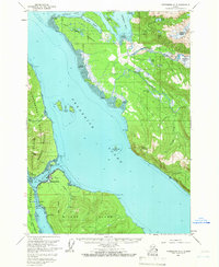
 2021 Petersburg D-3 SW2021 Print · USGSThe maritime communities of Petersburg and Kupreanof are shown in 2021 as they navigate the tidal waters of Wrangell Narrows. Genealogists and local historians can trace the town grid near the Petersburg Courthouse or locate the Petersburg Memorial Cem.
 - 2021 Map of Petersburg D-4 SE, 2021 Print
 2021 Petersburg D-4 SE2021 Print · USGSThe Lindenberg Peninsula and Kupreanof island are seen here in the early twenty-first century, showcasing a landscape of isolated peaks and coastal forest. Trace the winding Petersburg Lake Trl past Del Monte Peak to the waters of Colp Lake.
End of results
Showing maps 1-12 of 12
Top cities near Kupreanof
Frequently asked questions
- What are the different types of historical maps available for Kupreanof?
- What is the oldest map of Kupreanof?
- Where can I purchase historical maps of Kupreanof for my home or office?
- Where can I download high-res historical maps of Kupreanof?
- Are there historical topographic maps available for Kupreanof?
- Is there historical aerial imagery available for Kupreanof?
- Where are historical maps of Kupreanof sourced from?