Old Maps of Port Alexander, Alaska
Explore 14 old maps of Port Alexander, spanning from 1948 to today. These high-resolution historic maps reveal how streets, neighborhoods, landmarks, and natural features evolved over time — perfect for genealogy, metal detecting, research, and local history exploration.
What you can do with these maps:
- See how Port Alexander changed over time: Compare historical maps to modern-day views to trace roads, homesites, rail lines & more.
- View detailed metadata: Each map includes creators, publishers, year, scale, and archive source.
- Overlay maps with satellite & LiDAR: Visualize the past alongside modern tools to explore terrain & human change.
- Trusted historical sources: Maps sourced from the USGS, Library of Congress, and other archives.
- Access maps your way: View online, download high-res files, or order prints for personal or research use.
Start exploring old maps of Port Alexander to uncover forgotten places, hidden landmarks, and the deep history beneath your feet.
Port Alexander, AK maps
(14)- 1948 Map of Port Alexander A-2, 1958 Print
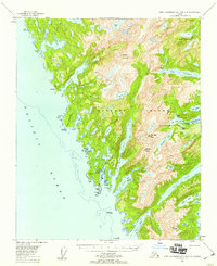
 1948 Port Alexander A-21958 Print · USGSThe southern tip of Baranof Island and the isolated outpost of Port Alexander are captured here in the late forties. Maritime historians and genealogists can trace the waterfront settlement, the local Cem, and landmarks like Cape Ommaney.
 - 1948 Map of Port Alexander B-2, 1958 Print
 1948 Port Alexander B-21958 Print · USGSBaranof Island and the waters of Chatham Strait are captured in the late 1940s, showing the remote maritime outposts of Southeast Alaska. Trace the coastal developments at Port Alexander and Port Armstrong, or find the secluded Cabin near New Port Walter.
 - 1951 Map of Port Alexander B-3 and B-4, 1959 Print
 1951 Port Alexander B-3 and B-41959 Print · USGSSoutheast Alaska in the early fifties reveals a landscape of isolated maritime outposts and high alpine lakes on the southern reaches of Baranof Island. Researchers can trace the layout of Big Port Walter and Port Armstrong or locate remote landmarks like the Cabin near Sashin Lake.3 unique versions available
 - 1951 Map of Port Alexander, 1959 Print
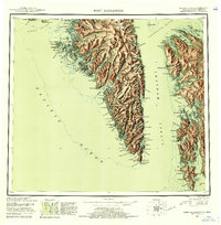
 1951 Port Alexander1959 Print · USGSSoutheast Alaska in the early fifties shows a rugged maritime landscape defined by isolated fishing outposts and steep coastal mountains. Trace the locations of historic settlements like Port Alexander, the Lodge at Crawfish Inlet, and the post office at Goddard (Hot Springs P O).5 unique versions available
 - 1951 Map of Port Alexander B-2, 1965 Print
 1951 Port Alexander B-21965 Print · USGSThe southeastern coast of Baranof Island is documented in the mid-fifties, showing the vital maritime hubs of Port Alexander and Port Walter. Researchers can find the Fisheries Research Station and the site of New Port Walter (ABAND).3 unique versions available
 - 1951 Map of Port Alexander A-2, 1975 Print
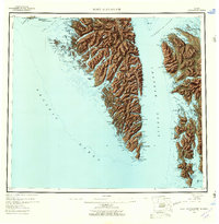
 1951 Port Alexander A-21975 Print · USGSBaranof Island and the coastal waters of Chatham Strait are documented in the early 1950s, centered on the fishing outpost of Port Alexander. Genealogists and researchers can locate the local Cem and coastal landmarks like Cape Ommaney and Breakfast Rock.
 - 1952 Map of Port Alexander, 1953 Print
 1952 Port Alexander1953 Print · USGSThe remote coastline of the First Judicial Division is documented here in the early fifties, featuring the isolated outpost of Port Alexander. Researchers can trace the maritime footprint of the era through scattered cabins, the Saginaw Bay Cannery, and the Lighthouse at Cape Decision.4 unique versions available
 - 1964 Map of Port Alexander
 1964 Port Alexander1964 Print · USGSSoutheast Alaska in the mid-1960s was a landscape of remote coastal outposts and cannery towns connected by the sea. Trace the maritime history of the Alexander Archipelago through sites like Goddard, the Pillar Bay Cannery, and the isolated Lighthouse at Cape Decision.
 - 2017 Map of Port Alexander B-3 SE, 2017 Print
 2017 Port Alexander B-3 SE2017 Print · USGSCovers Port Alexander, including Petersburg Borough, Sitka, and other nearby areas
 - 2017 Map of Port Alexander B-2 SW, 2017 Print
 2017 Port Alexander B-2 SW2017 Print · USGSCovers Port Alexander, including Port Armstrong, Petersburg Borough, and other nearby areas
 - 2017 Map of Port Alexander A-2 NW, 2017 Print
 2017 Port Alexander A-2 NW2017 Print · USGSCovers Port Alexander, including Petersburg Borough, Sitka, and other nearby areas
 - 2021 Map of Port Alexander B-3 SE, 2021 Print
 2021 Port Alexander B-3 SE2021 Print · USGSSoutheast Alaska’s coastal wilderness is captured here in the early twenty-first century, centered on the remote outpost of Port Alexander. Researchers can trace the mountainous terrain of the Tongass National Forest from Ptarmigan Peak down to the shores of Borodino Lake.
 - 2021 Map of Port Alexander A-2 NW, 2021 Print
 2021 Port Alexander A-2 NW2021 Print · USGSThe southern tip of Baranof Island comes into focus in this recent survey of the coastal wilderness. Maritime researchers and historians can trace the harbor at Port Alexander and locate landmarks like Cape Ommaney and Wooden Island along the shoreline.
 - 2021 Map of Port Alexander B-2 SW, 2021 Print
 2021 Port Alexander B-2 SW2021 Print · USGSCoastal life on Baranof Island is documented here as it appeared in the early 2020s. Map collectors and researchers can trace the maritime footprint of Port Alexander and Port Armstrong alongside features like Saveyard Cove.
End of results
Showing maps 1-14 of 14
Frequently asked questions
- What are the different types of historical maps available for Port Alexander?
- What is the oldest map of Port Alexander?
- Where can I purchase historical maps of Port Alexander for my home or office?
- Where can I download high-res historical maps of Port Alexander?
- Are there historical topographic maps available for Port Alexander?
- Is there historical aerial imagery available for Port Alexander?
- Where are historical maps of Port Alexander sourced from?