Old Maps of Attu Village, Alaska for Genealogy
Trace your family roots with 3 historic maps of Attu Village. These high-res maps reveal old neighborhoods, homesites, landmarks, and streets — helping you uncover where your ancestors lived and how the area evolved over time.
- Explore historic neighborhoods: Identify where your relatives may have lived in the 1800s or 1900s.
- Compare maps over time: Trace the changes in streets, buildings, and landmarks for multi-generational research.
- Perfect for genealogy & ancestry research: Used by family historians and researchers to map out lineage and migration.
These maps are an incredible resource for exploring your personal connection to Attu Village's past.
Attu Village, AK maps
(3)- 1952 Map of Attu
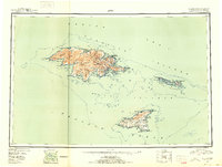 1952 Attu1952 Print · USGSThe westernmost Aleutians are shown in the years following the war, detailing the military footprint and geography of Attu Island. Researchers can find Navy Town, coastal defenses near Massacre Bay, and the high peaks of the Wrangell Range.3 unique versions available
 - 1953 Map of Attu, 1959 Print
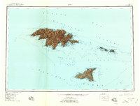 1953 Attu1959 Print · USGSThe westernmost Aleutian Islands are captured here in the post-war years, documenting the rugged geography of this Pacific frontier. Researchers can trace the coastline from Massacre Bay on Attu Island to the airfields and outposts on Shemya Island.6 unique versions available
 - 2021 Map of Attu C-3 NE, 2021 Print
 2021 Attu C-3 NE2021 Print · USGSThe remote Aleutian outpost of Attu is documented here in the early twenty-first century, showing the rugged topography between Chichagof Harbor and Hodikof Bay. Trace historic land features like the Japanese Gap and Holtz Sarana Pass.
End of results
Showing maps 1-3 of 3
Frequently asked questions
- What are the different types of historical maps available for Attu Village?
- What is the oldest map of Attu Village?
- Where can I purchase historical maps of Attu Village for my home or office?
- Where can I download high-res historical maps of Attu Village?
- Are there historical topographic maps available for Attu Village?
- Is there historical aerial imagery available for Attu Village?
- Where are historical maps of Attu Village sourced from?