Old Maps of Wood River, Dillingham for Academic Research
Study the evolution of Wood River with 5 high-resolution historic maps. Whether you're teaching, researching, or modeling changes in land use, these maps provide essential visual documentation of urban, environmental, and geographic change.
- Analyze long-term change: Track patterns in development, transportation, and natural features.
- Ideal for environmental or urban studies: Support academic projects with primary historical map data.
- Use in the classroom or lab: Educators and researchers rely on these maps to bring historical context to life.
These maps are a powerful tool for teaching, research, and visualizing how Wood River has changed over the decades.
Wood River, Dillingham maps
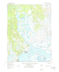
(5)- 1951 Map of Dillingham, 1952 Print
 1951 Dillingham1952 Print · USGSDillingham and the Bristol Bay river systems are captured here in the early fifties, showing a remote landscape linked by water and seasonal camps. Researchers can trace early settlements and post offices at New Stuyahok, Ekwok, and Kvichak.
 - 1952 Map of Dillingham A-7, 1963 Print
 1952 Dillingham A-71963 Print · USGSDillingham and the surrounding Bristol Bay coastline are captured in the early fifties during a period of vital regional growth. Researchers can trace the layout of Dillingham, locate the Kanakanak hospital, and follow the Winter Trail through the tundra.2 unique versions available
 - 1954 Map of Dillingham, 1967 Print
 1954 Dillingham1967 Print · USGSBristol Bay's interior river systems are mapped here in the mid-1950s, showing a landscape defined by water and winter travel. Researchers can trace remote settlements like Koliganek and Levelock or find family landmarks along the Nushagak River and Lake Aleknagik.3 unique versions available
 - 2019 Map of Dillingham A-7 SW, 2019 Print
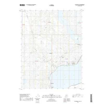 2019 Dillingham A-7 SW2019 Print · USGSCovers Wood River, including Dillingham, Nelsonville, and other nearby areas
 - 2023 Map of Dillingham A-7 SW, 2023 Print
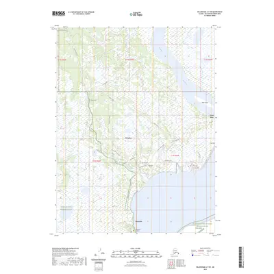 2023 Dillingham A-7 SW2023 Print · USGSDillingham and the surrounding coastal wetlands are captured here in the early twenty-first century, showing the town's modern footprint alongside the Bristol Bay shoreline. Researchers can trace the local road network and identify regional landmarks like Dillingham Airport, Nelsonville, and the Togiak National Wildlife Refuge.
End of results
Showing maps 1-5 of 5
Top cities near Wood River
Frequently asked questions
- What are the different types of historical maps available for Wood River?
- What is the oldest map of Wood River?
- Where can I purchase historical maps of Wood River for my home or office?
- Where can I download high-res historical maps of Wood River?
- Are there historical topographic maps available for Wood River?
- Is there historical aerial imagery available for Wood River?
- Where are historical maps of Wood River sourced from?