Old Maps of Wood River, Dillingham for Genealogy
Trace your family roots with 5 historic maps of Wood River. These high-res maps reveal old neighborhoods, homesites, landmarks, and streets — helping you uncover where your ancestors lived and how the area evolved over time.
- Explore historic neighborhoods: Identify where your relatives may have lived in the 1800s or 1900s.
- Compare maps over time: Trace the changes in streets, buildings, and landmarks for multi-generational research.
- Perfect for genealogy & ancestry research: Used by family historians and researchers to map out lineage and migration.
These maps are an incredible resource for exploring your personal connection to Wood River's past.
Wood River, Dillingham maps
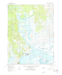
(5)- 1951 Map of Dillingham, 1952 Print
 1951 Dillingham1952 Print · USGSDillingham and the Bristol Bay river systems are captured here in the early fifties, showing a remote landscape linked by water and seasonal camps. Researchers can trace early settlements and post offices at New Stuyahok, Ekwok, and Kvichak.
 - 1952 Map of Dillingham A-7, 1963 Print
 1952 Dillingham A-71963 Print · USGSDillingham and the surrounding Bristol Bay coastline are captured in the early fifties during a period of vital regional growth. Researchers can trace the layout of Dillingham, locate the Kanakanak hospital, and follow the Winter Trail through the tundra.2 unique versions available
 - 1954 Map of Dillingham, 1967 Print
 1954 Dillingham1967 Print · USGSBristol Bay's interior river systems are mapped here in the mid-1950s, showing a landscape defined by water and winter travel. Researchers can trace remote settlements like Koliganek and Levelock or find family landmarks along the Nushagak River and Lake Aleknagik.3 unique versions available
 - 2019 Map of Dillingham A-7 SW, 2019 Print
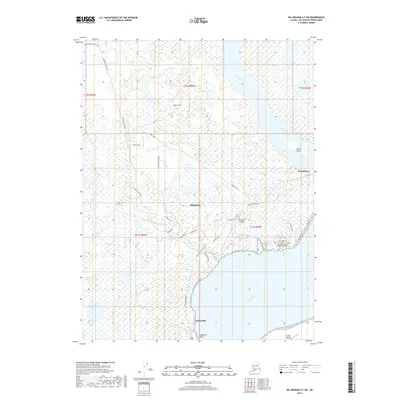 2019 Dillingham A-7 SW2019 Print · USGSCovers Wood River, including Dillingham, Nelsonville, and other nearby areas
 - 2023 Map of Dillingham A-7 SW, 2023 Print
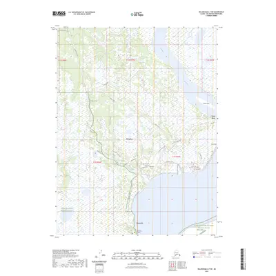 2023 Dillingham A-7 SW2023 Print · USGSDillingham and the surrounding coastal wetlands are captured here in the early twenty-first century, showing the town's modern footprint alongside the Bristol Bay shoreline. Researchers can trace the local road network and identify regional landmarks like Dillingham Airport, Nelsonville, and the Togiak National Wildlife Refuge.
End of results
Showing maps 1-5 of 5
Top cities near Wood River
Frequently asked questions
- What are the different types of historical maps available for Wood River?
- What is the oldest map of Wood River?
- Where can I purchase historical maps of Wood River for my home or office?
- Where can I download high-res historical maps of Wood River?
- Are there historical topographic maps available for Wood River?
- Is there historical aerial imagery available for Wood River?
- Where are historical maps of Wood River sourced from?