Old Maps of Evansville, Alaska for Academic Research
Study the evolution of Evansville with 8 high-resolution historic maps. Whether you're teaching, researching, or modeling changes in land use, these maps provide essential visual documentation of urban, environmental, and geographic change.
- Analyze long-term change: Track patterns in development, transportation, and natural features.
- Ideal for environmental or urban studies: Support academic projects with primary historical map data.
- Use in the classroom or lab: Educators and researchers rely on these maps to bring historical context to life.
These maps are a powerful tool for teaching, research, and visualizing how Evansville has changed over the decades.
Evansville, AK maps
(8)- 1951 Map of Bettles, 1952 Print
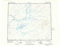 1951 Bettles1952 Print · USGSThe Koyukuk River valley appears in the early fifties as a landscape of isolated outposts and river-born travel. Trace the paths of the Winter Trail and the remote outposts at Bettles, Allakaket, and the Alatna Landing Area.
 - 1956 Map of Bettles, 1958 Print
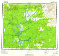 1956 Bettles1958 Print · USGSThe Alaskan interior during the mid-fifties reveals a landscape defined by winter trails and river navigation. Local historians can trace the foundations of Evansville, the neighboring communities of Allakaket and Alatna, and remote sites like Oscars Cabin.10 unique versions available
 - 1970 Map of Bettles D-4, 1973 Print
 1970 Bettles D-41973 Print · USGSThe Koyukuk River backcountry comes into focus during the early seventies, centered on the aviation and river hub of Evansville. Researchers can trace the Winter Trail and locate remote sites like the Bettles Cem, Bettles Field, and Pitchuk Lake.2 unique versions available
 - 1970 Map of Bettles D-3, 1973 Print
 1970 Bettles D-31973 Print · USGSThe Alaskan interior during the early seventies is revealed here through its network of seasonal transport and river systems. Researchers can trace the Winter Road and Winter Trail through the Whye Jack Range and locate landmarks like Four Corners.
 - 2016 Map of Bettles D-4 NE, 2016 Print
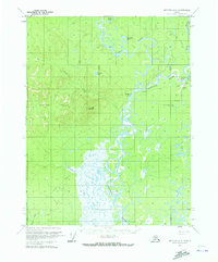
 2016 Bettles D-4 NE2016 Print · USGSCovers Evansville, including Bettles, Unorganized Borough, and other nearby areas
 - 2016 Map of Bettles D-3 NW, 2016 Print
 2016 Bettles D-3 NW2016 Print · USGSAlaska's Yukon-Koyukuk region comes into focus during the mid-2010s, centered on the settlement of Evansville. Trace the path of the Hickel Highway and the confluence near the Wild River and Koyukuk River.
 - 2016 Map of Bettles D-3 SW, 2016 Print
 2016 Bettles D-3 SW2016 Print · USGSThe Yukon-Koyukuk region of Interior Alaska is shown in this mid-2010s survey, highlighting the pristine wilderness before human settlement. Researchers can trace the meandering path of the South Fork Koyukuk River as it flows through the township of T22N R17W.
 - 2019 Map of Bettles D-4 NE, 2019 Print
 2019 Bettles D-4 NE2019 Print · USGSThe community of Bettles stands as a vital aviation and river junction in the Alaskan interior during the late twenty-teens. Researchers can trace the local road network around Bettles Airport and the seasonal Hickel Highway near the Koyukuk River.
End of results
Showing maps 1-8 of 8
Top cities near Evansville
Frequently asked questions
- What are the different types of historical maps available for Evansville?
- What is the oldest map of Evansville?
- Where can I purchase historical maps of Evansville for my home or office?
- Where can I download high-res historical maps of Evansville?
- Are there historical topographic maps available for Evansville?
- Is there historical aerial imagery available for Evansville?
- Where are historical maps of Evansville sourced from?