Old Maps of Kashiagamiut, Alaska for Metal Detecting
Plan your next treasure hunt with 4 historic maps of Kashiagamiut. Find old homesites, ghost towns, trails, and gathering spots that may be lost to time — perfect for identifying promising metal detecting locations.
- Locate forgotten sites: Uncover places like long-lost settlements, abandoned rail lines, or gathering spots.
- Plan better hunts: Use map overlays combined with LiDAR or satellite views to narrow in on historically rich areas.
- Made for detectorists: Thousands of hobbyists use these maps to discover relics, coins, and hidden history.
Use these historic maps to boost your research and find new opportunities beneath the surface of Kashiagamiut.
Kashiagamiut, AK maps
(4)- 1951 Map of Goodnews, 1953 Print
 1951 Goodnews1953 Print · USGSSouthwest Alaska’s coastal bays and mountain lakes are captured here just after the war, showing the area's shifting settlement patterns. Trace the coastline from Kwinhagak to Goodnews, or locate interior landmarks like the Placer Mine and Nuyakuk Lake.6 unique versions available
 - 1954 Map of Goodnews B-3, 1965 Print
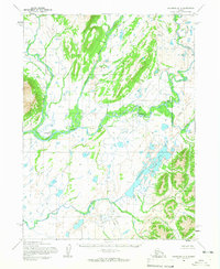 1954 Goodnews B-31965 Print · USGSSouthwestern Alaska's river systems are captured here in the mid-1950s, centering on the remote settlement of Kashiagamiut. Researchers can trace the braided paths of the Togiak River and its connections to Pungokepuk Lake and the Narogurum River.2 unique versions available
 - 1979 Map of Goodnews Bay
 1979 Goodnews Bay1979 Print · USGSCoastal villages and massive mountain ranges define the southwestern Alaska wilderness during the late seventies. Researchers can trace remote routes like the Winter Trail and locate isolated outposts at Platinum and Goodnews Bay near Cape Newenham.2 unique versions available
 - 2019 Map of Goodnews Bay B-3 SW, 2019 Print
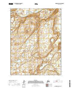 2019 Goodnews Bay B-3 SW2019 Print · USGSIn the river-connected tundra north of Goodnews Bay, this late twenty-first-century survey captures a landscape shaped by water and tradition. Researchers can trace the waterways near Kashiagamiut or follow the paths of the Togiak River and Pungokepuk Cr.
End of results
Showing maps 1-4 of 4
Frequently asked questions
- What are the different types of historical maps available for Kashiagamiut?
- What is the oldest map of Kashiagamiut?
- Where can I purchase historical maps of Kashiagamiut for my home or office?
- Where can I download high-res historical maps of Kashiagamiut?
- Are there historical topographic maps available for Kashiagamiut?
- Is there historical aerial imagery available for Kashiagamiut?
- Where are historical maps of Kashiagamiut sourced from?