1900s (20th Century) Maps of Kenny Lake, Alaska
Explore 5 historic maps of Kenny Lake from the 1900s (20th Century). These maps offer a rare glimpse into what life looked like during the 1900s — showing old roads, neighborhoods, homes, and landmarks that have changed or disappeared over time.
Whether you're researching your family's past, planning a metal detecting trip, or studying how Kenny Lake's landscape evolved across the 1900s, these high-resolution maps are a powerful tool for exploring the history of this region.
- Focus on a specific era: All maps on this page are from the 1900s, giving you a focused view of this time period.
- See what’s changed: Compare century-old streets, trails, and buildings to today's modern landscape using overlays and satellite layers.
- Research with precision: Use these maps for genealogy, historical research, land use analysis, or educational projects.
- View, download, or print: Maps are fully viewable online in high resolution, and can be downloaded or printed for your own records.
Start exploring Kenny Lake's history through authentic maps from the 1900s. This is your window into the past.
Kenny Lake, AK maps
(5)- 1951 Map of Valdez C-3, 1964 Print
 1951 Valdez C-31964 Print · USGSThe Copper River Valley in the early fifties shows a rugged Alaskan interior where settlement centered on Kenney Lake. Researchers can trace early infrastructure like the Copper River Highway and the remote terrain around Kimball Pass.3 unique versions available
 - 1952 Map of Valdez
 1952 Valdez1952 Print · USGSCoastal Alaska met the interior via mountain passes and river valleys during the mid-century, before the 1964 earthquake altered the shoreline. Trace mining history at Midas Camp and Cliff Mine, or locate remote stations like Tiekel Cache and Copper Center.4 unique versions available
 - 1953 Map of Valdez C-3, 1954 Print
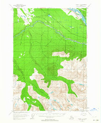
 1953 Valdez C-31954 Print · USGSThe Copper River basin comes into focus in the early 1950s as a landscape defined by glacial rivers and early road corridors. Follow the path of the Edgerton Cutoff past Kenney Lake and into the high country near Kimball Pass.2 unique versions available
 - 1960 Map of Valdez, 1967 Print
 1960 Valdez1967 Print · USGSCoastal and interior Alaska meet in this mid-century study of the Chugach Mountains and the copper-rich river valleys. Trace the legacy of early industry along the Copper River and Northwestern Railroad and locate settlements like Copper Center, Chitina, and Fort Liscum.6 unique versions available
 - 1996 Map of Valdez C-3, 2002 Print
 1996 Valdez C-32002 Print · USGSAlaskan interior wilderness and highway development meet in the 1990s as the Edgerton Highway skirts the northern mountain foothills. Researchers can trace the hydrology of the Tonsina River or locate the local Cemetery near Kenney Lake.
End of results
Showing maps 1-5 of 5
Frequently asked questions
- What are the different types of historical maps available for Kenny Lake?
- What is the oldest map of Kenny Lake?
- Where can I purchase historical maps of Kenny Lake for my home or office?
- Where can I download high-res historical maps of Kenny Lake?
- Are there historical topographic maps available for Kenny Lake?
- Is there historical aerial imagery available for Kenny Lake?
- Where are historical maps of Kenny Lake sourced from?