
1953 Map of Valdez C-3
USGS Topo · Published 1954About this map
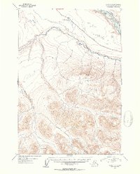
Tonsina River flows westward through a heavily glaciated landscape in this mid-century survey of the Copper River basin. The Edgerton Cutoff serves as the primary corridor for movement, skirting the northern edge of the terrain near Kenney Lake. The northern reach of the map is dominated by the wide, braided channels of the Copper River, where the silt-heavy waters carve through the valley floor. To the south, the topography rises sharply toward Kimball Pass, a natural high point between drainages. The drainage patterns of Dust Creek and Bernard Creek illustrate the watershed's complexity, showing a wild interior before the extensive modern infrastructure of the region was fully developed. This study was compiled from aerial photography taken in the early 1950s, capturing the remote character of the Alaska-Third Judicial Division during a period of expanding northern access.
Find a feature on this map
7 named features on this map. Tap any name to fly to it.
Don’t see what you’re looking for? This feature index may not catch every label — zoom into the map to look around manually.
Map Details
Editions of this 1953 Valdez C-3 Map
2 editions found
Other maps of this area

1949 · Valdez D-4
USGS Topo · 1:63,360

1951 · Valdez B-2
USGS Topo · 1:63,360

1951 · Valdez B-3
USGS Topo · 1:63,360

1951 · Valdez C-2
USGS Topo · 1:63,360

1951 · Valdez C-3
USGS Topo · 1:63,360

1951 · Valdez C-4
USGS Topo · 1:63,360

1951 · Valdez B-4
USGS Topo · 1:63,360

1952 · Valdez
USGS Topo · 1:250,000

1952 · Valdez D-4
USGS Topo · 1:63,360

1953 · Valdez C-2
USGS Topo · 1:63,360