
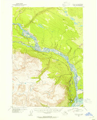
1953 Map of Valdez C-2
USGS Topo · Published 1954About this map
The confluence of the Copper River and Chitina River dominates this mid-century Alaskan landscape, revealing a period when transportation relied heavily on the Edgerton Cutoff. The settlement at Chitina is shown at the southeastern corner of the map, featuring a Cem and a nearby Air Strip that highlights the region's dependence on aerial access. To the west, Lower Tonsina sits along the Tonsina River, connected by road to several remote Cabin sites. The terrain is marked by significant elevation changes, from the braided riverbeds to the heights of VABM 4719 Liberty. Local landmarks like Liberty Falls and the Gravel Pit along the highway suggest the small-scale industrial and natural features that defined rural life in this part of the Alaska Territory.
Find a feature on this map
23 named features on this map. Tap any name to fly to it.
Don’t see what you’re looking for? This feature index may not catch every label — zoom into the map to look around manually.
Map Details
Editions of this 1953 Valdez C-2 Map
2 editions found
Other maps of this area

1951 · Valdez B-2
USGS Topo · 1:63,360

1951 · Valdez B-3
USGS Topo · 1:63,360

1951 · Valdez B-1
USGS Topo · 1:63,360

1951 · Valdez C-2
USGS Topo · 1:63,360

1951 · Valdez C-3
USGS Topo · 1:63,360

1951 · Valdez C-1
USGS Topo · 1:63,360

1952 · Valdez
USGS Topo · 1:250,000

1953 · Valdez C-3
USGS Topo · 1:63,360

1953 · Valdez C-1
USGS Topo · 1:63,360

1958 · Valdez D-3
USGS Topo · 1:63,360