
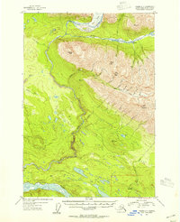
1953 Map of Valdez C-1
USGS Topo · Published 1954About this map
The Chitina River and the glacial-fed Kotsina River dominate this interior landscape, where mid-century Alaskan infrastructure follows the path of earlier industry. Evidence of the region's mining history is visible near Strelna, where an Old Railroad Grade skirts the northern banks of the Chitina. This transportation corridor once connected remote extraction sites to broader markets, a legacy reinforced by a solitary Mine located deep in the mountains near Copper Creek.
Find a feature on this map
38 named features on this map. Tap any name to fly to it.
Don’t see what you’re looking for? This feature index may not catch every label — zoom into the map to look around manually.
Map Details
Editions of this 1953 Valdez C-1 Map
2 editions found
Other maps of this area

1951 · McCarthy
USGS Topo · 1:250,000

1951 · Valdez B-2
USGS Topo · 1:63,360

1951 · Valdez B-1
USGS Topo · 1:63,360

1951 · McCarthy C-8
USGS Topo · 1:63,360

1951 · Valdez C-2
USGS Topo · 1:63,360

1951 · McCarthy B-8
USGS Topo · 1:63,360

1951 · Valdez C-1
USGS Topo · 1:63,360

1952 · Valdez
USGS Topo · 1:250,000

1953 · Valdez C-2
USGS Topo · 1:63,360

1959 · Valdez D-2
USGS Topo · 1:63,360