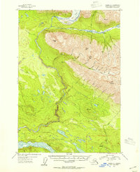
1953 Map of Valdez C-1
USGS Topo · Published 1954About this map
The Chitina River and Kotsina River valleys dominate this landscape, capturing a moment in the mid-1950s when the region's industrial past remained visible on the terrain. A notable Railroad Grade runs through the southern portion of the map, leading toward the settlement of Strelna, reflecting the importance of transportation corridors in this mineral-rich territory. High peaks such as Hubbard Peak and Alice Peak rise sharply above the watercourses, where a series of small cabins and a Mine near Elliott Creek suggest the persistence of prospecting and seasonal habitation.
Find a feature on this map
35 named features on this map. Tap any name to fly to it.
Don’t see what you’re looking for? This feature index may not catch every label — zoom into the map to look around manually.
Map Details
Editions of this 1953 Valdez C-1 Map
2 editions found
Other maps of this area

1951 · McCarthy
USGS Topo · 1:250,000

1951 · Valdez B-2
USGS Topo · 1:63,360

1951 · Valdez B-1
USGS Topo · 1:63,360

1951 · McCarthy C-8
USGS Topo · 1:63,360

1951 · Valdez C-2
USGS Topo · 1:63,360

1951 · McCarthy B-8
USGS Topo · 1:63,360

1951 · Valdez C-1
USGS Topo · 1:63,360

1952 · Valdez
USGS Topo · 1:250,000

1953 · Valdez C-2
USGS Topo · 1:63,360

1953 · Valdez C-1
USGS Topo · 1:63,360