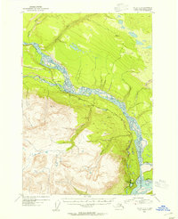
1953 Map of Valdez C-2
USGS Topo · Published 1954About this map
The Copper River dominates this mid-century Alaskan landscape, appearing as a sprawling braided system where it meets the Tonsina River and Chitina R. The settlement of Lower Tonsina sits at a critical junction where the Edgerton Cutoff crosses the river valley, marking a point of human infrastructure in an area otherwise defined by steep glacial-cut terrain and shifting riverbeds. To the north, the Cheshnina River winds through the flats, while the southern reaches are marked by the confluence with the Kotsina River. The presence of an Air Strip and a Gravel Pit near the river banks suggests the logistical activity necessary for maintaining remote roads and transportation during this era. High survey points like VABM 2064 Liberty and VABM 4719 Lynn overlook the deep valleys, providing a clear picture of the region's topography before modern development.
Find a feature on this map
18 named features on this map. Tap any name to fly to it.
Don’t see what you’re looking for? This feature index may not catch every label — zoom into the map to look around manually.
Map Details
Editions of this 1953 Valdez C-2 Map
2 editions found
Other maps of this area

1951 · Valdez B-2
USGS Topo · 1:63,360

1951 · Valdez B-3
USGS Topo · 1:63,360

1951 · Valdez B-1
USGS Topo · 1:63,360

1951 · Valdez C-2
USGS Topo · 1:63,360

1951 · Valdez C-3
USGS Topo · 1:63,360

1951 · Valdez C-1
USGS Topo · 1:63,360

1952 · Valdez
USGS Topo · 1:250,000

1953 · Valdez C-2
USGS Topo · 1:63,360

1953 · Valdez C-3
USGS Topo · 1:63,360

1953 · Valdez C-1
USGS Topo · 1:63,360