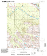
1996 Map of Valdez C-3
USGS Topo · Published 2002About this map
Kenney Lake sits at the northern edge of this landscape, serving as a primary point of reference along the Edgerton Highway. The terrain transitions from the developed corridor near the lake and its adjacent Cemetery toward the glacial-fed waters of the Tonsina River, which snakes across the center of the sheet. Further south, the elevation rises sharply toward the high peaks surrounding Kimball Pass, where smaller drainage systems like Dust Creek originate. To the east, the vast Wrangell-Saint Elias National Preserve encompasses the reach of the Copper River, marking a boundary between managed highway access and protected wilderness. The drainage patterns of Willow Creek and other tributaries illustrate the complex hydrology of this interior Alaskan region during the late twentieth century.
Find a feature on this map
9 named features on this map. Tap any name to fly to it.
Don’t see what you’re looking for? This feature index may not catch every label — zoom into the map to look around manually.
Map Details
Editions of this 1996 Valdez C-3 Map
This is the sole edition of this map. No revisions or reprints were ever made.
Other maps of this area

1949 · Valdez D-4
USGS Topo · 1:63,360

1951 · Valdez B-2
USGS Topo · 1:63,360

1951 · Valdez B-3
USGS Topo · 1:63,360

1951 · Valdez C-2
USGS Topo · 1:63,360

1951 · Valdez C-3
USGS Topo · 1:63,360

1951 · Valdez C-4
USGS Topo · 1:63,360

1951 · Valdez B-4
USGS Topo · 1:63,360

1952 · Valdez
USGS Topo · 1:250,000

1952 · Valdez D-4
USGS Topo · 1:63,360

1953 · Valdez C-2
USGS Topo · 1:63,360