Old Maps of Kongiganak, Alaska for Genealogy
Trace your family roots with 4 historic maps of Kongiganak. These high-res maps reveal old neighborhoods, homesites, landmarks, and streets — helping you uncover where your ancestors lived and how the area evolved over time.
- Explore historic neighborhoods: Identify where your relatives may have lived in the 1800s or 1900s.
- Compare maps over time: Trace the changes in streets, buildings, and landmarks for multi-generational research.
- Perfect for genealogy & ancestry research: Used by family historians and researchers to map out lineage and migration.
These maps are an incredible resource for exploring your personal connection to Kongiganak's past.
Kongiganak, AK maps
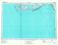
(4)- 1951 Map of Kuskokwim Bay
 1951 Kuskokwim Bay1951 Print · USGSThe coastal margins of the Bering Sea in the mid-century reveal a world of isolated settlements and river mouths. Researchers can trace the layout of Kwinhagak, Kipnuk, and Kongiganak along the reaches of Kuskokwim Bay and the Kanektok River.
 - 1954 Map of Kuskokwim Bay, 1967 Print
 1954 Kuskokwim Bay1967 Print · USGSCoastal life in western Alaska during the mid-fifties centered on river mouths and tundra lakes. Researchers can trace remote settlements like Kipnuk and Kongiganak or locate the Seaplane Anchorage used for essential regional transit.3 unique versions available
 - 1954 Map of Kuskokwim Bay D-3, 1971 Print
 1954 Kuskokwim Bay D-31971 Print · USGSCoastal Alaska in the mid-1950s is captured here at the edge of the Bering Sea, where the tide meets the delta. Researchers can trace seasonal routes like the Winter Trail and locate early footprints at Kongiganak (Site) or the isolated coastal Cabin.
 - 2018 Map of Kuskokwim Bay D-3 NE, 2018 Print
 2018 Kuskokwim Bay D-3 NE2018 Print · USGSThe coastal village of Kongiganak is documented in this 2018 survey, showing the community situated between the Kongiganak River and the open Pacific Ocean. Researchers can trace local transportation hubs like the Kongiganak Airport and the complex network of delta waterways.
End of results
Showing maps 1-4 of 4
Frequently asked questions
- What are the different types of historical maps available for Kongiganak?
- What is the oldest map of Kongiganak?
- Where can I purchase historical maps of Kongiganak for my home or office?
- Where can I download high-res historical maps of Kongiganak?
- Are there historical topographic maps available for Kongiganak?
- Is there historical aerial imagery available for Kongiganak?
- Where are historical maps of Kongiganak sourced from?