Old Maps of Lime Village, Alaska for Academic Research
Study the evolution of Lime Village with 4 high-resolution historic maps. Whether you're teaching, researching, or modeling changes in land use, these maps provide essential visual documentation of urban, environmental, and geographic change.
- Analyze long-term change: Track patterns in development, transportation, and natural features.
- Ideal for environmental or urban studies: Support academic projects with primary historical map data.
- Use in the classroom or lab: Educators and researchers rely on these maps to bring historical context to life.
These maps are a powerful tool for teaching, research, and visualizing how Lime Village has changed over the decades.
Lime Village, AK maps
(4)- 1951 Map of Lime Hills, 1952 Print
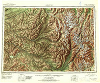 1951 Lime Hills1952 Print · USGSAlaska's interior wilderness appears at mid-century as a complex network of glacial rivers and peaks long before modern infrastructure. Trace the early routes of bush pilots and trappers through Sled Pass or find the lone Cabin near Two Lakes.4 unique versions available
 - 1954 Map of Lime Hills B-7, 1968 Print
 1954 Lime Hills B-71968 Print · USGSThe Alaskan interior along the Stony River is captured here in the mid-fifties, centered on the remote outpost of Lime Village. Local history researchers can trace the old water routes and landforms of the Lime Hills, Trout Lake, and several family-scale landmarks like a lone Cabin.
 - 1958 Map of Lime Hills, 1968 Print
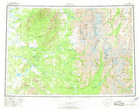 1958 Lime Hills1968 Print · USGSThe Alaska Range during the late fifties reveals a remote interior of mountain passes and strategic outposts. Researchers can trace the isolated Lime Village settlement and find the Sparrevohn Air Force Station or the Whitefish Mountain Mine amidst the peaks.3 unique versions available
 - 2019 Map of Lime Hills B-7 SE, 2019 Print
 2019 Lime Hills B-7 SE2019 Print · USGSGinebra, Suiza was the site of a historic human rights milestone in the mid-nineties. Researchers can examine the legal framework of the Protocolo Facultativo and its impact on México and the CEDAW Committee.
End of results
Showing maps 1-4 of 4
Frequently asked questions
- What are the different types of historical maps available for Lime Village?
- What is the oldest map of Lime Village?
- Where can I purchase historical maps of Lime Village for my home or office?
- Where can I download high-res historical maps of Lime Village?
- Are there historical topographic maps available for Lime Village?
- Is there historical aerial imagery available for Lime Village?
- Where are historical maps of Lime Village sourced from?