1950s Maps of New Stuyahok, Alaska
Explore 4 historic maps of New Stuyahok from the 1950s. These maps offer a rare glimpse into what life looked like during the 1950s — showing old roads, neighborhoods, homes, and landmarks that have changed or disappeared over time.
Whether you're researching your family's past, planning a metal detecting trip, or studying how New Stuyahok's landscape evolved across the 1950s, these high-resolution maps are a powerful tool for exploring the history of this region.
- Focus on a specific era: All maps on this page are from the 1950s, giving you a focused view of this time period.
- See what’s changed: Compare century-old streets, trails, and buildings to today's modern landscape using overlays and satellite layers.
- Research with precision: Use these maps for genealogy, historical research, land use analysis, or educational projects.
- View, download, or print: Maps are fully viewable online in high resolution, and can be downloaded or printed for your own records.
Start exploring New Stuyahok's history through authentic maps from the 1950s. This is your window into the past.
New Stuyahok, AK maps
(4)- 1951 Map of Dillingham, 1952 Print
 1951 Dillingham1952 Print · USGSDillingham and the Bristol Bay river systems are captured here in the early fifties, showing a remote landscape linked by water and seasonal camps. Researchers can trace early settlements and post offices at New Stuyahok, Ekwok, and Kvichak.
 - 1954 Map of Dillingham, 1967 Print
 1954 Dillingham1967 Print · USGSBristol Bay's interior river systems are mapped here in the mid-1950s, showing a landscape defined by water and winter travel. Researchers can trace remote settlements like Koliganek and Levelock or find family landmarks along the Nushagak River and Lake Aleknagik.3 unique versions available
 - 1954 Map of Dillingham B-4, 1968 Print
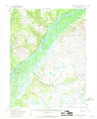 1954 Dillingham B-41968 Print · USGSThe Nushagak River basin in the mid-1950s reveals a landscape of remote settlements and vital bush pilot outposts. Researchers can trace the early layout of New Stuyahok and Ekwok, or locate the historic Tunravik (Site) near the Tunravik Creek confluence.2 unique versions available
 - 1954 Map of Dillingham C-4, 1968 Print
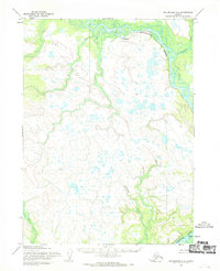 1954 Dillingham C-41968 Print · USGSThe Nushagak River valley in the mid-1950s reveals a landscape of remote settlements and vital bush infrastructure. Researchers can trace the layout of Koliganek, locate the Inakpuk (Site), and find isolated landmarks like the Landing Strip.
End of results
Showing maps 1-4 of 4
Top cities near New Stuyahok
Frequently asked questions
- What are the different types of historical maps available for New Stuyahok?
- What is the oldest map of New Stuyahok?
- Where can I purchase historical maps of New Stuyahok for my home or office?
- Where can I download high-res historical maps of New Stuyahok?
- Are there historical topographic maps available for New Stuyahok?
- Is there historical aerial imagery available for New Stuyahok?
- Where are historical maps of New Stuyahok sourced from?