Old Maps of Takotna, Alaska for Metal Detecting
Plan your next treasure hunt with 5 historic maps of Takotna. Find old homesites, ghost towns, trails, and gathering spots that may be lost to time — perfect for identifying promising metal detecting locations.
- Locate forgotten sites: Uncover places like long-lost settlements, abandoned rail lines, or gathering spots.
- Plan better hunts: Use map overlays combined with LiDAR or satellite views to narrow in on historically rich areas.
- Made for detectorists: Thousands of hobbyists use these maps to discover relics, coins, and hidden history.
Use these historic maps to boost your research and find new opportunities beneath the surface of Takotna.
Takotna, AK maps
(5)- 1951 Map of Iditarod, 1952 Print
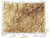 1951 Iditarod1952 Print · USGSThe Iditarod and Innoko river basins are captured here during the early fifties, showing the historic heart of the interior gold country. Researchers can trace seasonal travel routes and placer mining sites near Iditarod, Flat, and Dikeman.4 unique versions available
 - 1954 Map of Iditarod D-1, 1967 Print
 1954 Iditarod D-11967 Print · USGSInterior Alaska in the mid-fifties is captured here during a time of strategic military expansion and continued resource extraction. Researchers can trace the rugged Winter Trail, locate the Takotna Air Force Station, and find evidence of mining along Ganes Creek.2 unique versions available
 - 1955 Map of Iditarod D-1, 1958 Print
 1955 Iditarod D-11958 Print · USGSThe Takotna River valley in the mid-1950s shows a landscape of military outposts and mining operations. Researchers can trace the early layout of Takotna, identify the location of a Placer Mine, and follow the Winter Trail through the interior hills.
 - 1956 Map of Iditarod, 1965 Print
 1956 Iditarod1965 Print · USGSInterior Alaska in the mid-fifties reveals a landscape of mining camps and military outposts. Trace the remnants of the gold rush at Iditarod, find placer mines near Flat, and see the early Takotna Air Force Station.3 unique versions available
 - 2019 Map of Iditarod D-1 NE, 2019 Print
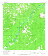
 2019 Iditarod D-1 NE2019 Print · USGSThe remote interior of Alaska comes into focus during the late 2010s at the river crossing of Takotna. Researchers can trace the vital transport corridors of the Sterling Landing / Takotna / Ophir Road and locate the Takotna Airport along the Takotna River.
End of results
Showing maps 1-5 of 5
Frequently asked questions
- What are the different types of historical maps available for Takotna?
- What is the oldest map of Takotna?
- Where can I purchase historical maps of Takotna for my home or office?
- Where can I download high-res historical maps of Takotna?
- Are there historical topographic maps available for Takotna?
- Is there historical aerial imagery available for Takotna?
- Where are historical maps of Takotna sourced from?