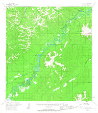
1954 Map of Iditarod D-1
USGS Topo · Published 1967About this map
The Takotna River meanders through this remote interior landscape, creating a complex network of oxbows and wetlands during the mid-1950s. High ground is defined by the prominent Takotna Mountain and Mount Joaquin, while the drainage basins of Ganes Creek and Yankee Creek show evidence of industrial activity with a Placer Mine located in the northwest corner. This period of Alaskan history is marked by the strategic importance of the Takotna Air Force Station, situated on a high ridge overlooking the valley. Transportation across the difficult terrain relies on a Winter Trail and a remote Landing Strip, reflecting the isolation of the region before the expansion of more permanent road networks. Local geography is further detailed by numerous smaller waterways including Beef Steak Creek, July Creek, and the Totalina River.
Find a feature on this map
18 named features on this map. Tap any name to fly to it.
Don’t see what you’re looking for? This feature index may not catch every label — zoom into the map to look around manually.
Map Details
Editions of this 1954 Iditarod D-1 Map
2 editions found
Other maps of this area

1949 · McGrath
USGS Topo · 1:250,000

1950 · Medfra
USGS Topo · 1:250,000

1950 · McGrath
USGS Topo · 1:250,000

1951 · Ophir
USGS Topo · 1:250,000

1951 · Iditarod
USGS Topo · 1:250,000

1954 · Medfra A-6
USGS Topo · 1:63,360

1954 · Ophir A-2
USGS Topo · 1:63,360

1954 · McGrath D-6
USGS Topo · 1:63,360

1954 · Ophir A-1
USGS Topo · 1:63,360

1954 · McGrath C-6
USGS Topo · 1:63,360