
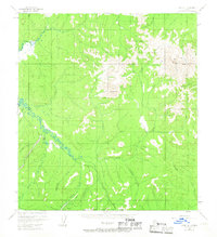
1954 Map of Ophir A-1
USGS Topo · Published 1958About this map
The Innoko River winds through the heart of this interior Alaska territory, where 1950s mapping reveals a landscape shaped by remote industrial activity and water management. Evidence of the region's mining heritage is prominent along the southern drainages, specifically at the Placer Mine near Yankee Creek and Independence Creek. A notable Ditch system runs parallel to the watercourses, indicating the extensive hydraulic infrastructure required for placer operations in this permafrost environment.
Find a feature on this map
19 named features on this map. Tap any name to fly to it.
Don’t see what you’re looking for? This feature index may not catch every label — zoom into the map to look around manually.
Map Details
Editions of this 1954 Ophir A-1 Map
2 editions found
Other maps of this area

1949 · McGrath
USGS Topo · 1:250,000

1950 · Medfra
USGS Topo · 1:250,000

1950 · McGrath
USGS Topo · 1:250,000

1951 · Ophir
USGS Topo · 1:250,000

1951 · Iditarod
USGS Topo · 1:250,000

1954 · Medfra A-6
USGS Topo · 1:63,360

1954 · Ophir A-2
USGS Topo · 1:63,360

1954 · McGrath D-6
USGS Topo · 1:63,360

1954 · Medfra B-6
USGS Topo · 1:63,360

1954 · Iditarod D-2
USGS Topo · 1:63,360