
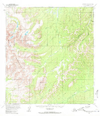
1954 Map of Iditarod D-2
USGS Topo · Published 1965About this map
The Beaver Mountains dominate this interior Alaska landscape, captured during a mid-century period of topographical mapping by the Geological Survey. The region is defined by its seasonal access and gold-mining activity, with a Summer Trail and Winter Trail providing the primary overland routes. Near the northeastern corner, the Ganes Creek Landing Strip serves as a critical connection for the Placer Mine operations along the drainage of Ganes Creek.
Find a feature on this map
15 named features on this map. Tap any name to fly to it.
Don’t see what you’re looking for? This feature index may not catch every label — zoom into the map to look around manually.
Map Details
Editions of this 1954 Iditarod D-2 Map
2 editions found
Other maps of this area

1951 · Ophir
USGS Topo · 1:250,000

1951 · Iditarod
USGS Topo · 1:250,000

1954 · Ophir A-2
USGS Topo · 1:63,360

1954 · Ophir A-1
USGS Topo · 1:63,360

1954 · Iditarod C-3
USGS Topo · 1:63,360

1954 · Iditarod C-2
USGS Topo · 1:63,360

1954 · Ophir A-3
USGS Topo · 1:63,360

1954 · Iditarod D-3
USGS Topo · 1:63,360

1954 · Ophir
USGS Topo · 1:250,000
1954 · Iditarod D-1
USGS Topo · 1:63,360