
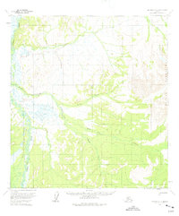
1954 Map of Iditarod D-3
USGS Topo · Published 1965About this map
The Beaver Mountains dominate the eastern reaches of this interior Alaskan landscape, their high ridges giving way to a complex drainage system that feeds the Dishna River. Surveyed in the mid-1950s using photogrammetric methods from 1953 aerial photography, the map documents a territory defined by seasonal waterways and overland routes. The Hunter Trail cuts across the northern terrain, reflecting the era's reliance on established pack trails for movement through the bush. Evidence of human presence is sparse, marked only by a solitary Cabin in the southeast, situated near the headwaters of a tributary. The network of named streams, including Billy Goat Creek, Windy Creek, and Moose Creek, illustrates how geography was often mapped through the perspective of the hunters and trappers who navigated these valleys before modern infrastructure reached the region.
Find a feature on this map
10 named features on this map. Tap any name to fly to it.
Don’t see what you’re looking for? This feature index may not catch every label — zoom into the map to look around manually.
Map Details
Editions of this 1954 Iditarod D-3 Map
2 editions found
Other maps of this area

1951 · Ophir
USGS Topo · 1:250,000

1951 · Iditarod
USGS Topo · 1:250,000

1954 · Ophir A-2
USGS Topo · 1:63,360

1954 · Iditarod C-4
USGS Topo · 1:63,360

1954 · Iditarod C-3
USGS Topo · 1:63,360

1954 · Iditarod C-2
USGS Topo · 1:63,360

1954 · Iditarod D-2
USGS Topo · 1:63,360

1954 · Ophir A-3
USGS Topo · 1:63,360

1954 · Ophir A-4
USGS Topo · 1:63,360

1954 · Iditarod D-4
USGS Topo · 1:63,360