1950s Maps of Takotna, Alaska
Explore 4 historic maps of Takotna from the 1950s. These maps offer a rare glimpse into what life looked like during the 1950s — showing old roads, neighborhoods, homes, and landmarks that have changed or disappeared over time.
Whether you're researching your family's past, planning a metal detecting trip, or studying how Takotna's landscape evolved across the 1950s, these high-resolution maps are a powerful tool for exploring the history of this region.
- Focus on a specific era: All maps on this page are from the 1950s, giving you a focused view of this time period.
- See what’s changed: Compare century-old streets, trails, and buildings to today's modern landscape using overlays and satellite layers.
- Research with precision: Use these maps for genealogy, historical research, land use analysis, or educational projects.
- View, download, or print: Maps are fully viewable online in high resolution, and can be downloaded or printed for your own records.
Start exploring Takotna's history through authentic maps from the 1950s. This is your window into the past.
Takotna, AK maps
(4)- 1951 Map of Iditarod, 1952 Print
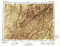 1951 Iditarod1952 Print · USGSThe Iditarod and Innoko river basins are captured here during the early fifties, showing the historic heart of the interior gold country. Researchers can trace seasonal travel routes and placer mining sites near Iditarod, Flat, and Dikeman.4 unique versions available
 - 1954 Map of Iditarod D-1, 1967 Print
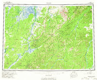
 1954 Iditarod D-11967 Print · USGSInterior Alaska in the mid-fifties is captured here during a time of strategic military expansion and continued resource extraction. Researchers can trace the rugged Winter Trail, locate the Takotna Air Force Station, and find evidence of mining along Ganes Creek.2 unique versions available
 - 1955 Map of Iditarod D-1, 1958 Print
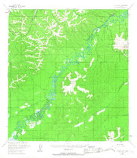
 1955 Iditarod D-11958 Print · USGSThe Takotna River valley in the mid-1950s shows a landscape of military outposts and mining operations. Researchers can trace the early layout of Takotna, identify the location of a Placer Mine, and follow the Winter Trail through the interior hills.
 - 1956 Map of Iditarod, 1965 Print
 1956 Iditarod1965 Print · USGSInterior Alaska in the mid-fifties reveals a landscape of mining camps and military outposts. Trace the remnants of the gold rush at Iditarod, find placer mines near Flat, and see the early Takotna Air Force Station.3 unique versions available
End of results
Showing maps 1-4 of 4
Frequently asked questions
- What are the different types of historical maps available for Takotna?
- What is the oldest map of Takotna?
- Where can I purchase historical maps of Takotna for my home or office?
- Where can I download high-res historical maps of Takotna?
- Are there historical topographic maps available for Takotna?
- Is there historical aerial imagery available for Takotna?
- Where are historical maps of Takotna sourced from?