Old Maps of Teller, Alaska for Hiking & Exploration
Hike through history with 8 historic maps of Teller. Explore old trails, ghost towns, and forgotten backroads — perfect for outdoor adventurers and local explorers.
- Rediscover forgotten places: Map out old mining camps, roads, and footpaths that no longer exist on modern maps.
- Layer with modern tools: Combine with LiDAR or satellite views to plan hikes through historical terrain.
- Made for exploration: Popular among hikers, overlanders, and local history lovers.
Use these maps to find adventure and explore the hidden past of Teller.
Teller, AK maps
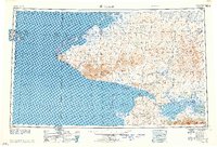
(8)- 1950 Map of Teller, 1956 Print
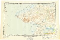 1950 Teller1956 Print · USGSThe Seward Peninsula at the dawn of the fifties showcases the remote outposts of the far northwest before modern expansion. Researchers can trace early settlements and outposts like Tin City, the Teller Mission, and the native village at Wales.8 unique versions available
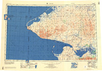
 - 1950 Map of Teller A-3, 1957 Print
 1950 Teller A-31957 Print · USGSThe Seward Peninsula coastal interior comes into focus during the mid-century, showing a landscape defined by seasonal transit and mining prospects. Local history researchers can trace the Winter Trail network and locate sites like Sullivan Camp and Gold Run.3 unique versions available
 - 1950 Map of Teller B-3, 1957 Print
 1950 Teller B-31957 Print · USGSThe Seward Peninsula shoreline comes into focus during the early 1950s, centered on the coastal settlement of Teller. Genealogists and researchers can trace the seasonal Winter Trail routes connecting Teller Mission with inland landmarks like Eva Mountain and the Agiapuk River.4 unique versions available
 - 1951 Map of Teller, 1952 Print
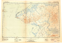 1951 Teller1952 Print · USGSThe westernmost tip of the Seward Peninsula is charted here in the early fifties, where the American mainland faces the Diomede Islands across the Bering Strait. Researchers can locate remote outposts like Tin City, the Sullivan (Mining Camp), and the settlement at Wales.2 unique versions available
 - 1957 Map of Teller
 1957 Teller1957 Print · USGSThe westernmost edge of the Seward Peninsula at the edge of the Cold War era shows the proximity of the Diomede Islands to the mainland. Researchers can trace coastal settlements like Wales and Teller alongside the Brevig Trail and Teller Mission.
 - 1958 Map of Teller
 1958 Teller1958 Print · USGSThe tip of the Seward Peninsula is documented here during the late fifties, showing the remote coastal outposts and the international boundary in the Bering Strait. Trace the Winter Trail through the York Mountains to settlements like Wales, York, and Teller.
 - 2014 Map of Teller B-3 SW, 2014 Print
 2014 Teller B-3 SW2014 Print · USGSCoastal life on the Seward Peninsula comes into focus in this early twenty-first-century survey of the waters around Port Clarence. Trace the infrastructure of the far north through the Brevig Mission Airport, the streets of Teller, and the historic Teller-Cape Prince of Wales Trail.
 - 2017 Map of Teller A-3 NW, 2017 Print
 2017 Teller A-3 NW2017 Print · USGSCoastal Alaska at the edge of the Seward Peninsula comes into focus in the early twenty-first century as modern infrastructure meets the tundra. Trace the vital corridor of the Nome-Teller Highway past Cape Riley and the Teller Airport.
End of results
Showing maps 1-8 of 8
Top cities near Teller
Frequently asked questions
- What are the different types of historical maps available for Teller?
- What is the oldest map of Teller?
- Where can I purchase historical maps of Teller for my home or office?
- Where can I download high-res historical maps of Teller?
- Are there historical topographic maps available for Teller?
- Is there historical aerial imagery available for Teller?
- Where are historical maps of Teller sourced from?