1990s Maps of Troweek, Arizona
Explore 2 historic maps of Troweek from the 1990s. These maps offer a rare glimpse into what life looked like during the 1990s — showing old roads, neighborhoods, homes, and landmarks that have changed or disappeared over time.
Whether you're researching your family's past, planning a metal detecting trip, or studying how Troweek's landscape evolved across the 1990s, these high-resolution maps are a powerful tool for exploring the history of this region.
- Focus on a specific era: All maps on this page are from the 1990s, giving you a focused view of this time period.
- See what’s changed: Compare century-old streets, trails, and buildings to today's modern landscape using overlays and satellite layers.
- Research with precision: Use these maps for genealogy, historical research, land use analysis, or educational projects.
- View, download, or print: Maps are fully viewable online in high resolution, and can be downloaded or printed for your own records.
Start exploring Troweek's history through authentic maps from the 1990s. This is your window into the past.
Troweek, AZ maps
(2)- 1991 Map of Escudilla Mountain
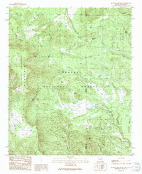 1991 Escudilla Mountain1991 Print · USGSHigh-altitude wilderness and forest lands define the Arizona-New Mexico border in the 1990s. Researchers can trace remote alpine hydrology and landmarks from Profanity Ridge to the waters of Romero Lake and McFate Spring.
 - 1997 Map of Escudilla Mountain, 2000 Print
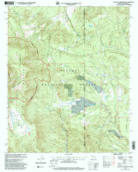 1997 Escudilla Mountain2000 Print · USGSHigh-altitude peaks and the Arizona-New Mexico state line define this wilderness area during the late nineties. Local history hunters can trace early water management at ELC Flat Tank and landmarks like Profanity Ridge or the Cinder Pit.
End of results
Showing maps 1-2 of 2
Top cities near Troweek
Frequently asked questions
- What are the different types of historical maps available for Troweek?
- What is the oldest map of Troweek?
- Where can I purchase historical maps of Troweek for my home or office?
- Where can I download high-res historical maps of Troweek?
- Are there historical topographic maps available for Troweek?
- Is there historical aerial imagery available for Troweek?
- Where are historical maps of Troweek sourced from?