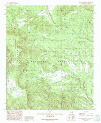
1991 Map of Escudilla Mountain
USGS Topo · Published 1991About this map
Escudilla Mountain dominates this high-altitude landscape along the border of Arizona and New Mexico in the early 1990s. The topography is defined by the protected expanse of the Escudilla Wilderness and the Apache National Forest, where steep ridgelines like Profanity Ridge drop into the deep basin of the Punchbowl. This survey details an intricate network of alpine water sources, from high-country lakes like Lake Erin and Romero Lake to numerous named seeps such as McFate Spring and Sawmill Spring. The map documents the boundary where Apache County meets Catron County, tracing the transition from peaks like Turner Peak down to Steele Flat. The prevalence of cienegas, such as Flanigan Cienega, highlights the critical meadow-and-spring ecosystems that supported cattle and wildlife in this portion of the White Mountains range.
Find a feature on this map
41 named features on this map. Tap any name to fly to it.
Don’t see what you’re looking for? This feature index may not catch every label — zoom into the map to look around manually.
Map Details
Editions of this 1991 Escudilla Mountain Map
This is the sole edition of this map. No revisions or reprints were ever made.
Other maps of this area

1886 · St Johns
USGS Topo · 1:250,000

1892 · St Johns
USGS Topo · 1:250,000

1915 · Reserve
USGS Topo · 1:125,000

1918 · Reserve
USGS Topo · 1:125,000

1922 · Nutrioso
USGS Topo · 1:125,000

1954 · Clifton
USGS Topo · 1:250,000

1954 · Saint Johns
USGS Topo · 1:250,000

1957 · Clifton
USGS Topo · 1:250,000

1957 · Saint Johns
USGS Topo · 1:250,000

1958 · Clifton
USGS Topo · 1:250,000