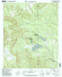
1997 Map of Escudilla Mountain
USGS Topo · Published 2000About this map
Escudilla Mountain and its surrounding peaks dominate this high-altitude landscape along the border of Apache and Catron counties. The survey captures the complex topography of the Escudilla Wilderness, where dramatic landforms like Profanity Ridge and the deep Punchbowl descend toward ELC Flat. The terrain is marked by numerous water sources essential for high-country survival, including Lake Erin, Romero Lake, and McFate Spring.
Find a feature on this map
40 named features on this map. Tap any name to fly to it.
Don’t see what you’re looking for? This feature index may not catch every label — zoom into the map to look around manually.
Map Details
Editions of this 1997 Escudilla Mountain Map
This is the sole edition of this map. No revisions or reprints were ever made.
Other maps of this area

1886 · St Johns
USGS Topo · 1:250,000

1892 · St Johns
USGS Topo · 1:250,000

1915 · Reserve
USGS Topo · 1:125,000

1918 · Reserve
USGS Topo · 1:125,000

1922 · Nutrioso
USGS Topo · 1:125,000

1954 · Clifton
USGS Topo · 1:250,000

1954 · Saint Johns
USGS Topo · 1:250,000

1957 · Clifton
USGS Topo · 1:250,000

1957 · Saint Johns
USGS Topo · 1:250,000

1958 · Clifton
USGS Topo · 1:250,000