1990s Maps of Nicksville, Sierra Vista
Explore 2 historic maps of Nicksville from the 1990s. These maps offer a rare glimpse into what life looked like during the 1990s — showing old roads, neighborhoods, homes, and landmarks that have changed or disappeared over time.
Whether you're researching your family's past, planning a metal detecting trip, or studying how Nicksville's landscape evolved across the 1990s, these high-resolution maps are a powerful tool for exploring the history of this region.
- Focus on a specific era: All maps on this page are from the 1990s, giving you a focused view of this time period.
- See what’s changed: Compare century-old streets, trails, and buildings to today's modern landscape using overlays and satellite layers.
- Research with precision: Use these maps for genealogy, historical research, land use analysis, or educational projects.
- View, download, or print: Maps are fully viewable online in high resolution, and can be downloaded or printed for your own records.
Start exploring Nicksville's history through authentic maps from the 1990s. This is your window into the past.
Nicksville, Sierra Vista maps
(2)- 1994 Map of Nogales
 1994 Nogales1994 Print · USGSThe Arizona-Sonora borderlands come into focus in the mid-1990s, showcasing the intricate Spanish land grants and mining districts that shaped the region. Genealogists and historians can trace old mining camps like Washington Camp and Duquesne or locate the historic Mowry Mine.2 unique versions available
 - 1996 Map of Nicksville, 2002 Print
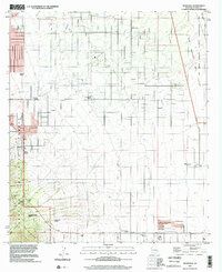 1996 Nicksville2002 Print · USGSThis late-twentieth-century survey of the Arizona borderlands captures a landscape of cattle ranches and rugged canyons on the edge of the Huachuca Mountains. Genealogists and local historians can trace family-named properties like Smiling Tiger Ranch and Wilcox Ranch alongside the Baumkirchner Mine.
End of results
Showing maps 1-2 of 2
Top cities near Nicksville
Frequently asked questions
- What are the different types of historical maps available for Nicksville?
- What is the oldest map of Nicksville?
- Where can I purchase historical maps of Nicksville for my home or office?
- Where can I download high-res historical maps of Nicksville?
- Are there historical topographic maps available for Nicksville?
- Is there historical aerial imagery available for Nicksville?
- Where are historical maps of Nicksville sourced from?