1980s Maps of Kaibito, Arizona
Explore 5 historic maps of Kaibito from the 1980s. These maps offer a rare glimpse into what life looked like during the 1980s — showing old roads, neighborhoods, homes, and landmarks that have changed or disappeared over time.
Whether you're researching your family's past, planning a metal detecting trip, or studying how Kaibito's landscape evolved across the 1980s, these high-resolution maps are a powerful tool for exploring the history of this region.
- Focus on a specific era: All maps on this page are from the 1980s, giving you a focused view of this time period.
- See what’s changed: Compare century-old streets, trails, and buildings to today's modern landscape using overlays and satellite layers.
- Research with precision: Use these maps for genealogy, historical research, land use analysis, or educational projects.
- View, download, or print: Maps are fully viewable online in high resolution, and can be downloaded or printed for your own records.
Start exploring Kaibito's history through authentic maps from the 1980s. This is your window into the past.
Kaibito, AZ maps
(5)- 1981 Map of Horsethief Mesa, 1982 Print
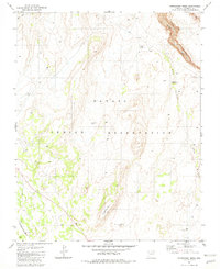 1981 Horsethief Mesa1982 Print · USGSThe high plateau of the Navajo Indian Reservation is captured here in the early 1980s, showing a landscape defined by water and rock. Researchers can trace land use through features like Red Bluff Windmill, the eponymous Horsethief Mesa, and several scattered Corral sites.
 - 1981 Map of Kaibito, 1982 Print
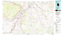
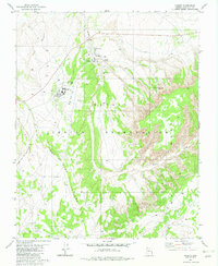 1981 Kaibito1982 Print · USGSIn the Coconino County highlands during the early eighties, this area shows the essential hubs of the Navajo community. Genealogists and historians can trace the foundations of local education and life at the Old Kaibito Boarding Sch, the Rodeo Grounds, and Juniper Well.
 - 1982 Map of White Hill
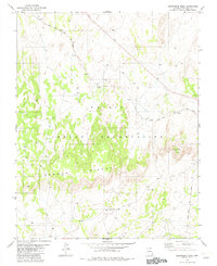
 1982 White Hill1982 Print · USGSThe high mesas of the Navajo Nation are documented in the early eighties as a working landscape of ranching and remote outposts. Researchers can locate specific water improvements and grazing landmarks like the Lined Trees Windmill, Dejolie Tank, and several corrals.
 - 1982 Map of Arrowhead Mesa
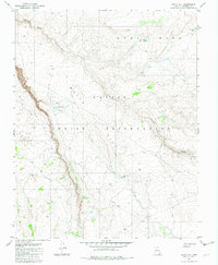
 1982 Arrowhead Mesa1982 Print · USGSCoconino County is captured in the early eighties as a corridor of transit and traditional lands within the Navajo Indian Reservation. Trace the path of the Black Mesa and Lake Powell rail line past Wind Rock and the Mormon Ridges.
 - 1984 Map of Glen Canyon Dam
 1984 Glen Canyon Dam1984 Print · USGSThe Colorado River corridor near the Utah border is captured here in the mid-eighties, centered on the rise of modern infrastructure in the desert. Researchers can trace the development of Page alongside historic sites like Lees Ferry and the Copper Mine Trading Post.2 unique versions available
End of results
Showing maps 1-5 of 5
Top cities near Kaibito
Top neighborhoods of Kaibito
Frequently asked questions
- What are the different types of historical maps available for Kaibito?
- What is the oldest map of Kaibito?
- Where can I purchase historical maps of Kaibito for my home or office?
- Where can I download high-res historical maps of Kaibito?
- Are there historical topographic maps available for Kaibito?
- Is there historical aerial imagery available for Kaibito?
- Where are historical maps of Kaibito sourced from?