1930s Maps of Diamond Point Summer Homes, Arizona
Explore 2 historic maps of Diamond Point Summer Homes from the 1930s. These maps offer a rare glimpse into what life looked like during the 1930s — showing old roads, neighborhoods, homes, and landmarks that have changed or disappeared over time.
Whether you're researching your family's past, planning a metal detecting trip, or studying how Diamond Point Summer Homes's landscape evolved across the 1930s, these high-resolution maps are a powerful tool for exploring the history of this region.
- Focus on a specific era: All maps on this page are from the 1930s, giving you a focused view of this time period.
- See what’s changed: Compare century-old streets, trails, and buildings to today's modern landscape using overlays and satellite layers.
- Research with precision: Use these maps for genealogy, historical research, land use analysis, or educational projects.
- View, download, or print: Maps are fully viewable online in high resolution, and can be downloaded or printed for your own records.
Start exploring Diamond Point Summer Homes's history through authentic maps from the 1930s. This is your window into the past.
Diamond Point Summer Homes, AZ maps
(2)- 1934 Map of Promontory Butte, 1955 Print
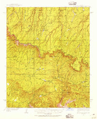 1934 Promontory Butte1955 Print · USGSThe Mogollon Rim country of Gila and Coconino Counties is captured in the mid-thirties, showcasing a network of remote homesteads and forest service outposts. Trace family history and early mountain life at sites like the Zane Grey Lodge, Haught Sawmill, and the Fred Haught Cabin.
 - 1939 Map of Promontory Butte
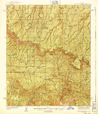 1939 Promontory Butte1939 Print · USGSArizona's rim country comes alive in the late 1930s, showing the early ranches and forest outposts that predated modern recreation. Trace the locations of historic homesteads like Zane Grey Lodge, the Haught Sawmill, and the Buck Springs Guard Station.3 unique versions available
End of results
Showing maps 1-2 of 2
Top cities near Diamond Point Summer Homes
Frequently asked questions
- What are the different types of historical maps available for Diamond Point Summer Homes?
- What is the oldest map of Diamond Point Summer Homes?
- Where can I purchase historical maps of Diamond Point Summer Homes for my home or office?
- Where can I download high-res historical maps of Diamond Point Summer Homes?
- Are there historical topographic maps available for Diamond Point Summer Homes?
- Is there historical aerial imagery available for Diamond Point Summer Homes?
- Where are historical maps of Diamond Point Summer Homes sourced from?