1930s Maps of Payson, Arizona
Explore 2 historic maps of Payson from the 1930s. These maps offer a rare glimpse into what life looked like during the 1930s — showing old roads, neighborhoods, homes, and landmarks that have changed or disappeared over time.
Whether you're researching your family's past, planning a metal detecting trip, or studying how Payson's landscape evolved across the 1930s, these high-resolution maps are a powerful tool for exploring the history of this region.
- Focus on a specific era: All maps on this page are from the 1930s, giving you a focused view of this time period.
- See what’s changed: Compare century-old streets, trails, and buildings to today's modern landscape using overlays and satellite layers.
- Research with precision: Use these maps for genealogy, historical research, land use analysis, or educational projects.
- View, download, or print: Maps are fully viewable online in high resolution, and can be downloaded or printed for your own records.
Start exploring Payson's history through authentic maps from the 1930s. This is your window into the past.
Payson, AZ maps
(2)- 1934 Map of Pine
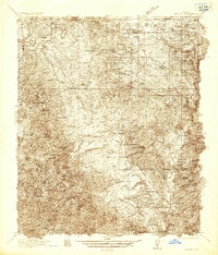
 1934 Pine1934 Print · USGSIn the mid-1930s, the dramatic Mogollon Rim divided Arizona's high timberlands from the rugged canyon country. Genealogists and historians can trace early mountain life through the Crackerjack Mine, the Natural Bridge, and the Chase Ranch.2 unique versions available
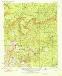
 - 1936 Map of Payson
 1936 Payson1936 Print · USGSThe high-desert ranches and rugged mining claims of Gila County are captured here in the mid-1930s. Genealogists and historians can locate early family homesteads like the Seventy-Six Ranch and remote school sites such as Gisela Sch.3 unique versions available
End of results
Showing maps 1-2 of 2
Top cities near Payson
Top neighborhoods of Payson
Frequently asked questions
- What are the different types of historical maps available for Payson?
- What is the oldest map of Payson?
- Where can I purchase historical maps of Payson for my home or office?
- Where can I download high-res historical maps of Payson?
- Are there historical topographic maps available for Payson?
- Is there historical aerial imagery available for Payson?
- Where are historical maps of Payson sourced from?